Stage Coach Travel Misery December 22nd

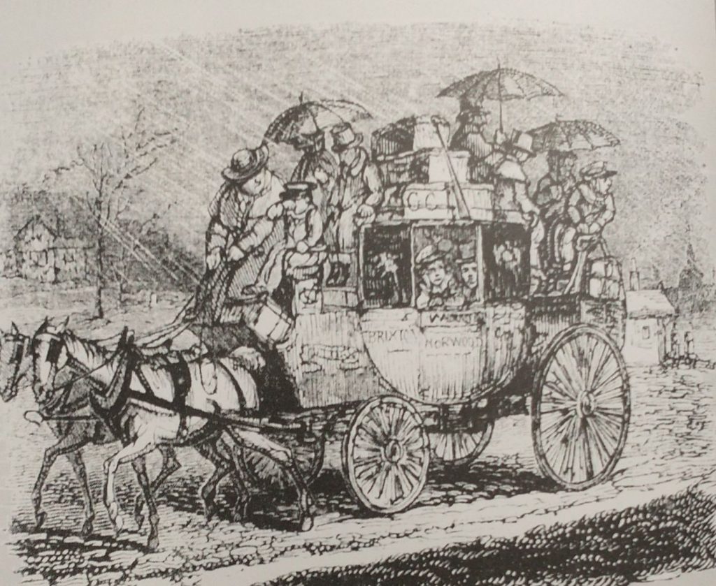
As the Sun enters the House of Capricorn remember the poor Coachman travelling all day everyday in all weathers. Washington Irving in his ‘Old Christmas’ (Originally ‘The Sketch Book of Geoffrey Crayon’ pub. 1819) describes him with a broad red face, a broad body widened by drinking beer; swathed with any numbers of layers of coats trying to keep the cold out. He has many worries on his mind as he has a coach full not only of people who need looking after but also a lot of parcels and commissions that need to be carried out in the many stops along the way. He is delivering parcels, turkeys, geese, presents, children, you name it he is responsible for its safe delivery.

Feel sorry for the people crowded inside the carriage but even sorrier for those sitting on the roof. They have umbrellas in a vain attempt to keep dry, but the umbrella tines will be poking you in your ear, and the run off from the canopy of the umbrella might trickle down your neck. There might be 6 people inside and up to 10 on the roof. 3d for travelling inside and half of that for the roof. voach

Inside, you are next to a large man who is not very salubrious looking, nor too worried about pressing his thighs against you.

John Keats blamed his consumption on his journey on the roof of a stage-coach travelling from London to Hampstead on a cold wet day in February.

Stage coaches became regular sights on the road during the 17th Century and were quite dangerous as the roads were in such a poor condition. It was suggested that passengers made their wills before travelling! From the late 17th and with Parliament increasingly used to set up not-for-profit toll road, the roads got better, and ‘Flyers’ and mail coaches could get up to the tremendous speed of 10 miles an hour, and averaging 7. This happened because improved roads meant improved suspensions, and wheels, and more and faster horses could be harnessed.

This revolutionized travel. It used to take 5 days in around 1700 to get to Manchester from London, by the mid 18th Century the time taken was reduced to 24 hours, and there were many more scheduled coaches, The mail coaches had priority, the coach had a blunderbuss and two pistols to deter highway men, and the guard had a post-horn with which to warn other vehicles to give clear passage, to alert tollgate keepers to open gates, and to announce arrival at a stop. Extra horses would be harnessed to help get up steep hills which, in some cases, like Broadway in the Cotswolds, might mean an additional 10 horses. Passengers might be asked not only to get off the coach to lighten the load but also to push if the going got boggy. On mail coaches, the passengers were not allowed to get off when the horses were changed, and only 4 were allowed inside the coach.

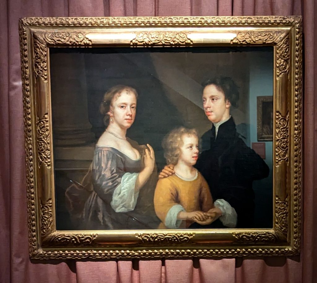
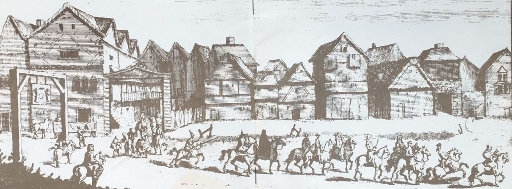
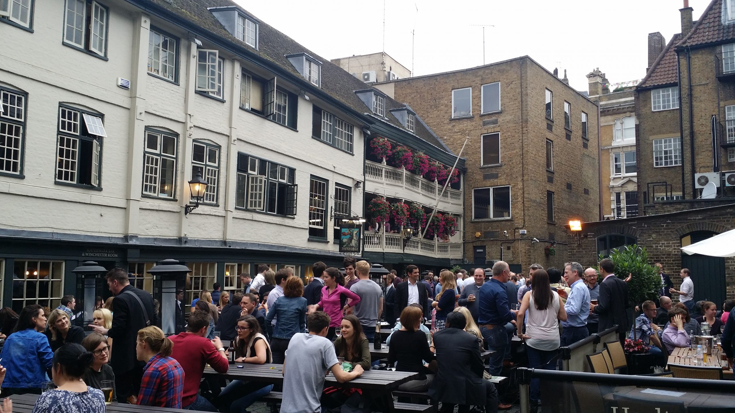
London was ringed by Coaching Inns, which were coach terminals and hotels. The most famous ones, remaining, are in Southwark on the approach road to London Bridge. The Tabard where the Chaucer’s Canterbury Tales started, The White Hart where Dickens’ Sam Wheeler is the Bootboy, and the George, which although not quite so literary is at least still half intact.

Pilgrims leaving the Tabard for the Canterbury Pilgrimage
Pilgrims leaving the Tabard Inn for the Canterbury Pilgrimage
George Inn,Southwark
George Inn,Southwark (photo Kevin Flude)

Capricorn

‘The man born under Capricorn shall be iracundious and a fornicator; a liar, and always labouring.

....The woman shall be honest and fearful, and have children of three men, she will do many pilgrimages in her youth and after have great wit.’

From Kalendar of Shepheards 1604 quoted in ‘The Perpetual Almanac of Folklore by Charles Kightly’.

iracundious is first mentioned in a work published by Caxton in the 15th Century and pretty much obselete by the 17th Century. It means easily angered or irritable.

First published in 2023 and revised in 2024

Cures for the Bewitched – November 7th

A Witch bottle and Contents on display at Greenwich Tourist information Centre

This post failed to publish on the 7th November, so here it is:

As we are between Halloween, and Halloween Old Style the chances of bewitchment are high what with all those spirits being out and about on this – the most uncanny of all times. So, you might want to look at ‘Doctor Lilly’s Last Legacy’ of 1683 which gives a cure for those who have been bewitched at Halloween.

Take two horseshoes, beat them red-hot and nail one on the threshold of the door, but Quench the other in the Urine of the party bewitched: then set the urine over the fire in a pot or Pipkin and put the horseshoe into it. Make the urine boil with a little salt put onto it, and three horseshoe nails until it is almost all consumed: what is not boiled away cast into the fire. Keep then your horseshoes and nails in a clean paper or cloth and use the same manner three times. It will be the more effectual if is done at the change or full of the Moon.

Doctor Lilly’s Last Legacy, Online at the Wellcome Collection, although you will need a login to view it. I found it first in my favourite source, Perpetual Almanac of the Year by Charles Kightly.

Doctor Lilly’s Last legacy ‘Being the poor man’s physician, the sick man’s friend, and the country-man’s doctor’.

Items like this make me wonder about the gullibility of the human being, but I guess we are surrounded by examples of the lack of sense of a large proportion of our species. Perhaps I should rephrase this, I think most people make sensible decisions about their day-to-day life, but many do not have the critical thinking skills to evaluate the bigger issues.

For more on keeping witches away, witches’ marks etc. have a look at this post of mine.

Discovering Mary Beale in Pall Mall, Flaming June in Piccadilly March 26th

Philip Mould Galley,Bond Street.The home of painter Mary Beale

The painter Mary Beale was born on March 26th 1633 in Barrow.

Last year, I was asked to do two Jane Austen’s London walks.  The walk explores Mayfair, where her brother, Henry lived and had his Bank, and where Austen placed the central drama of Sense and Sensibility. I decided to use the time between the walks to look for a shopping mall which dates back to Jane Austen’s time, but I got diverted as I saw a sign for a free exhibition on Mary Beale in Pall Mall. 

Mary Beale is that rare beast; a professional female artist of the 17th Century (1633-1699). So, I double-checked the ‘free entry’ notice because this was a posh West End private art gallery and the name Philip Mould was familiar.  I went in and realised that this was something special. I returned to the entrance to ask the very friendly staff whether I could take photographs.  ‘Yes, of course, they said.’ much to my surprise.

Mary Beale Exhibition sign.

Downstairs, the art of Mary Beale was beautifully displayed, and the exhibition had a very interesting story to tell, which was well-told, using excellent labels and a film narrated by Philip Mould.  He was, as I thought, the co-presenter of ‘Fake or Fortune’ (with Fiona Bruce, newsreader and anchor of the BBC’s Antiques Roadshow). This is a BBC art programme which is in its 12th Series. The conceit of the show is that they investigate dubious paintings to find out whether they are genuine or not.

The film revealed that Philip Mould opened his Art Gallery here over a decade ago, but research has recently discovered that this is the very address where Mary Beale had her studio.

Scene shot of Philip Mould in the Mary Beale Exhibition in his short film shot in his Art Gallery.

Her career is not only remarkable in itself, but it was recorded in great detail by her husband. She was the bread winner.  He was her partner, and in effect the studio manager. In correspondence, he describes her as his ‘dearest heart’. 

Self-Portrait of Mary, with her husband and son

It was a family business and their children also worked as painting assistants, doing draperies and other background details.   Her paintings gave them an income of around £200 a year, which is not riches but, by comparison, a labourer got about £30 a year.

She was associated with Sir Peter Lely, the Court painter who succeeded Van Dyke. Mary Beale made copies of many of his paintings.  She also painted many pictures of her family.

Mary Beale’s painting after Sir Peter Lely’s portrait of Charles II

There are several excellent short films about Mary Beale on the Gallery’s web site, which is well worth a visit. The exhibition ends on the 19th July, but there is also, for you to see, Tate Britain’s exhibition ‘Now you see us’ which is the story of British female artists from the 1520’s to 1920.

On continued this walk to the Royal Academy when I encountered the painting ‘Flaming June’ by Lord Leighton – I removed the content to its own page which you can see here

Town exploration: 4 Brussels

Modern map of central Brussels.  The Bourse is a red circle near the centre.

The map of the centre of Brussels shows the area where I have identified topographical evidence of an early Wall circuit. The two red lines coming from the top left point to a red rectangle which is on the curved road called ‘Vieux Marché aux Grains’. This road follows the curved line of the NE section of the wall and was confirmed by the discovery of a surviving section of the Wall on it (see previous posts).

So, on my 4th and last day in Brussels I want to find the rest of this circuit. If you look at the map you can convince yourself there is a circular route – Rue des Riches Clares (Street of the Clare nuns); Rue des Teinturies (Street of Dyers); Kolenmarkt (Coal Market) and to the Grand Place. But I can find nothing that proves it and its a bit weird to have the Town Square (Grand Place) of the town outside the circuit. Maybe this is because the Bourse was the original centre of gravity I wondered? Whatever the case, the roads have the irregularity of medieval town centre streets.

The Town  Hall Grand Place, Brussels
The Town Hall Grand Place, Brussels

It started to rain so decided to see about a guided tour of the Town Hall, but the attendant suggested I’d be better off at the free ‘House of the King’ across the square which I discover with rising excitement is subtitled ‘The Brussels City Museum.’ Initially I’m disappointed as it is full of fragments of Gothic statues, but upstairs, I strike pay dirt with not only maps, engravings and photographs of the Old Wall Circuit but also a massive model.

Model of 13th Century Wall Circuit of Brussels.
Model of 13th Century Wall Circuit of Brussels. (looking South West)

It takes me a lot of time to work out what is what and which direction we are looking. But the section of the wall at the bottom of the photo above is the wall I identified on the Vieux Marché aux Grains. St Catherine’s is the Church seen just inside the Wall, just to the left of the Gate at the middle bottom of the photo. Other evidence makes it clear that the present day St Catherine’s was moved a little to the left (east).

So, a confirmation of sorts, but also a revelation, in that a river is flowing just behind the wall, and the wall circuit is much bigger than I suspected.

The River is the Senne, it was navigable to an extent taking 8 days to take cargoes to the River Schelde. The River is completely gone, and I think the other part of the wall I pencilled in was actually not the wall but roads following the route of the River.

The River Senne, originally the reason for the foundation of Brussels, became a stinking sewer and was filled in leaving no trace, except the roads that ran alongside it or replaced it.

Detail labelled copy of panoramic painting of Brussels c1665 by Jean-Baptiste Bonnercroy.  Looking South West

The River was augmented and then replaced by a Canal, which reduced the journey time to the Schelde to one day. The Canal came into the expanded City at no 29 (above_ which is the River gate of the 2nd Wall circuit, and, you might just be able to see a wide street going diagonally from 29 towards no 26, which is St Catherine’s Church. This street used to be the new canal, now a dry linear park and market place.

Detail of Braun & Hogenberg map of 1572, showing the canal entering at Porte De Rivage.

At the end of the canal was a T-Junction so that boats could turn around. When this was filled in and reclaimed St Catherine’s was moved and rebuilt in this space. The Wall was just south of the t-Junction and No 30 in the panorama is the Black Tower, part of the original 13th Century Wall Circuit.

St Catherine’s, built over the old t-junction of the canal. The photo is taken from what was once the canal.

But back to my search for the 13th Century Walk circuit. Look below at the whole model you will see how wrong I was about a small roundish early wall circuit.

Model of 13th Century Wall Circuit of Brussels.

This view of the town is the opposite direction to the previous one, so the wall in the far distance was the section I correctly identified. But I had absolutely no idea that the walled area was so large. The bulge in the wall at the front of the picture was on high ground and was original the site of the Duke of Brabant’s Castle, on Coundenberg Hill and founded in the 11th Century. My exploration was not particularly successful, as far as the 13th Century circuit was concerned, as I had no idea where most of the wall circuit was. I was thinking that there must have been a castle on top of the Hill, but didn’t think the wall circuit would be that big.

Brussels itself began as a small trading town on the River Senne and in the marshy valley of the River. It collected grain from the rich area to export to Antwerp and other urban centres.

Braun and Hogenberg Plan of Brussels, 1572 showing both wall circuits. North east at the bottom of the plan

The map above shows the two wall circuits. The earliest built 1210 -1230 and the large circuit built in 1357 -1383. That later was extensively developed with the addition of demi-lunettes in 1578, and turned into full bastions in 1671 to cope with the increasing power of artillery. The letters on the plan refer to pictures of the wall that survive.

Panoramic painting of Brussels c1665 by Jean-Baptiste Bonnercroy.  Looking South West

The second wall circuit can clearly be seen in the picture above, with Porte de Flandres in the centre, and demi-lunettes in front of the 14th Century Wall.

I finished the exploration by finally getting into the 14th Century Gate – Porte de Halle which was wall worth the two trips.

Porte de Halles

This image below will give a good idea of the final form of the defences before they were almost totally demolished and replaced by a ring road.

The late 17th Century Defences of Brussels.

So all in all Brussels is a very interesting City with great museums, amazing pubs/bars, fabulous remains of Art Nouveau dotted around, and an interesting history. As to my exploration, very enjoyable, a little disappointed I didn’t find the River, or identify more of the 13th Century Circuit. With another day I would have walked the entire 13th and 14th Century circuits. But I suspect the surgeon who did my hernia operation would have thought I overdid it as it was.

Town exploration: 3 Brussels

modern map of central Brussels.  The Bourse is a red circle near the centre.

So my next task is to confirm the earlier wall circuit on the map. 

To remind you I have tentatively identified the street called the’ Vieux Marché aux Grains’ as a section of an earlier wall circuit surrounding Brussels.  On the map above the two red lines coming from the top left point to a red rectangle which is on the Vieux Marché.  Walking along it you soon come to a beautiful church dedicated to St Catherine.  It must be either just inside, just outside or on top of my walk circuit.

St Catherine’s, Brussels

I walk into the church, photograph lots of saints and walk out and there just beyond it is the confirmation that I’m right.  There is a beautiful interval Tower and, just to make it certain, it has sections of wall coming out from it.  So this the earlier wall circuit.  Looks medieval, a century or two earlier than the Porte de Halles.

The Black Tower, Brussels

So, I’m feeling pleased with myself.  Two wall circuits confirmed, the outer one I know where the entire circuit is and that it has all been swept away and replaced by an urban ring road except a couple (?) of fragments.

The inner circuit I have only confirmed one section, I know one more bit of it exists or did exist but pretty sure not much else.  I’m thinking from the street pattern that it is a small roundish circuit, but nothing is clear from the street pattern apart from this one street.

Feeling smug although I am aware this is a strange game I play with myself.  I could just Google ‘Brussels Town Walls’ and I would have most of the answers instantly but the fun of the game is to find it out yourself through topographical clues. 

I do it, I think, partly to honour my friend, David Bentley, who died of motor neurone disease a good few years ago but not before we had many stimulating discussions on topographical clues to urban history.  Also, it really helps you understand the City, it will tell you why particular roads are important, and give the history of the growth of the town.  Since I lost David it is often a solitary game as it needs a very tolerant person to put up with following leads to frequent dead ends and someone who can share the thrill of finding a small fragment of ‘wall’ in exactly the predicted place.

One more discovery before I end.  There is a linear ‘park’ coming down from the Porte Flandres, it is lined with what remind me of canalside houses in Bruges, and this seems to be the original route of the canal that was built to link Brussels to the Scheldt.  I was told that the canal was diverted when they built the new walk circuit so this seems to be the original course.  It comes down to the side of St Catherine’s.

Filled in Canal leading to St Catherine’s.  Fish restaurants to the right and you can just see the Black Tower to the left of the Church.

I have no idea how the boats turned around but the grain market was to the right and the fish restaurants suggest this is where fish were landed.

Tomorrow, you will find out if my smugness is confirmed after I decide it is time to  check the facts and leave speculation behind.

Town exploration: 2 Brussels

Panoramic painting of Brussels c1665 by Jean-Baptiste Bonnercoy. 

So I arrived at the hotel in Brussels.  Got their free map and looked for likely Wall circuits.

Creased Map of Brussels

As you will see there is an extensive inner ring road or boulevard clearly marked in orange.    This is, I thought probably  the Renaissance wall alignment when the town had expanded and the old walls became useless in the face of cannons. 

A closer look at the map confirms it was a wall circuit as at junctions there is a grey label saying ‘Porte de Flandres’ or similar. 

So the next task is to find if there was an earlier wall circuit on the map.  I’m basically looking for curved roads that were originally just inside the walls or just outside.

modern map of central Brussels.  The Bourse is a red circle near the centre.

The two red lines coming from the top left point to a red rectangle which is my hotel and by chance is on a curved road which is my guess to be the early wall circuit.  It is called the ‘Vieux Marché aux Grains’. I had a quick explore before retiring for the night. But found nothing conclusive and St Catherine’s Church is astride it.

At breakfast, in the basement I failed to notice that 3 of  the 4 walls were ancient stone, and there was a picture of a wall and bastion tower.  These were pointed out by a staff member, and they suggested they were part of the wall.

Basement cafe of Hotel Atlas

The walls in the basement formed three sides of a rectangle so I had my doubts whether it was ‘the wall’ but it could be a tower or a building built up against the wall. But the picture certainly confirmed my guess that this curved street marked the route of the early wall.

Picture of the wall

So next I walked up to the ‘Porte de Flandres’ in the north east of the town on what I am calling the Renaissance circuit. I wanted to see if any gate or wall survived (no) and to look at the canal which runs alongside the wall. 

Then to visit Brussels amazing museums where in the Old Masters museum was found the view of the walls that you will find above.  The view is from the north east and at the bottom you will see the canal that linked Brussels to the main trade routes with triangular ramparts in front designed to withstand cannon fire, with the canal and the wall behind. Right in the centre of the bottom is the Porte de Flandres. It looks 15th Century to me, give or take a century but the triangular ramparts look 17th Century.

At the Museum were leaflets to a Porte de Halle museum, So I went from the Musee d’Arte et D’ Histoire, through the European Parliament to the old Wall circuit past several old gates which no longer exist and then saw the view below of the Porte de Halle.

Porte de Halle, Brussels

It looks like something from the Très Riches Heures du Duc de Berry which is early 15th Century. I couldn’t confirm because the gatekeeper of the Porte refused entry as, he said, last entry was at 4pm (1 arrived at 4.03pm) although the leaflet clearly says last entry is 45 mins prior to closing at 5pm.

So I went to confirm the existence of the earlier wall circuit. And I will post about that later.

Googling yourself to find your book is no 4 in a list of ‘Top Ten History Books’ of 2015!

Now here is the sort of thing you find out about yourself only if you

a. google yourself
b. go down to page 8

And there I find that thebookbag had my book as no 4 in its top ten history books of 2015, with Mary Beard at no 2.

And this is their review:

‘Divorced, Beheaded, Died…: The History of Britain’s Kings and Queens in Bite-Sized Chunks by Kevin Flude

4.5star.jpg

History lives. Proof of that sweeping statement can be had in this book, and in the fact that while it only reached the grand old age of six, it has had the dust brushed off it and has been reprinted – and while the present royal incumbent it ends its main narrative with has not changed, other things have. This has quietly been updated to include the reburial of Richard III in Leicester, and seems to have been re-released at a perfectly apposite time, as only the week before I write these words the Queen has surpassed all those who came before her as our longest serving ruler. Such details may be trivia to some – especially those of us of a more royalist bent – and important facts to others. The perfect balance of that coupling – trivia and detail – is what makes this book so worthwhile.’

135,000 copies to date in 7 editions and formats. I did suggest a new updated edition to add a section on King Charles III but they said ‘they had no plans.’

http://www.thebookbag.co.uk/reviews/Top_Ten_History_Books_2015

‘New’ Portrait of Shakespeare on sale for £10m?

Robert Peake Portrait of a Man aged 44 in 1608

It’s not a ‘new’ portrait as it has been known about for many years, but it is in the news as it is about to be sold. Evidence for it being our main man, include:

  • In 1608 Shakespeare was 44 (as inscribed on the top of the painting)
  • He is balding
  • He has a long nose
  • He has a fold of the skin to the left of his left eye
  • The two had convincing connections (people and places) in common
  • The Peake family printed the Droeshout Portrait used in the First Folio
  • Testing shows it is not a forgery

However, it doesn’t really look like the two Shakespeare portraits we can trust to be him (the Droeshout and the bust on his memorial in Holy Trinity Stratford where he was buried). But if someone pays £10m maybe we will change our minds?

For more information follow this link.

https://www.yorkshirepost.co.uk/heritage-and-retro/heritage/william-shakespeare-only-signed-and-dated-image-of-famous-playwright-hung-in-yorkshire-stately-home-3919872