Salon IF reported a shocking destruction in France – this is the report, verbatim from Salon IF issue 514.
Dozens of standing stones, erected over 7,000 years ago, have been demolished to make way for a DIY store near Carnac, in Brittany, in North West France. Some 37 stones, measuring between 0.5 – 1.5m tall, were removed despite the fact the site had long been on France’s National Archaeological Map. The stones, moreover, had been submitted to the tentative list of UNESCO World Heritage Sites (although the application had not yet been approved).
The region of Carnac is famous for its ancient ‘menhir’ – heavy, raised standing stones. Indeed, the area is often described as ‘the French Stonehenge’, with over 3,000 stone megaliths at the two sites of Menec and Kermario. There, the stone columns are arranged in long, straight rows and, according to the Carnac Tourist Office, it is the largest gathering of this type of standing stone in the world.
The land at the centre of the recent controversy, along the Montauban activity zone, had been granted a building permit by the local mayor’s office in August 2022 and construction of the new store, ‘Mr Bricolage’, was already underway. According to local amateur archaeologist, Christian Obeltz, who had originally raised concerns about the ‘brutal developments’, a bulldozer destroyed the stones overnight.
The Regional Office of Cultural Affairs for Brittany, the body responsible for the protection of the monument, said ‘Given the uncertain and in any case non-major character of the remains, as revealed by
checks, damage to a site of archaeological value has not been established’, but Obeltz maintains that archaeological investigation into the area had not been sufficient.
‘The Chemin de Montauban site included two intersecting rows of small granite stelae, each spreading out over fifty meters in length. One had been exactly in its original place for 7,000 years,’ according to Obletz. ‘The small menhirs of the Chemin de Montauban were undoubtedly one of the oldest sets of stelae in the town of Carnac’ believed to date between 5480 and 5320 BC, ‘the highest dating obtained for a menhir in the west of France’.
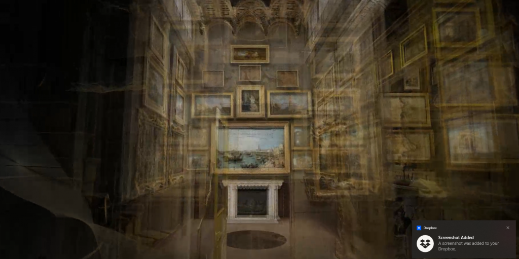
Screen Shot of the Virtual Tour of the Sir John Soane Museum
The Sir John Soane Museum is my second favourite London Museum. It’s the place I choose to take people who don’t know London. What I like about it is the atmosphere. It’s not a place I go because of the collection, it’s a place I go because I’m just awestruck when I enter the doors.
Architect Soane, made a Museum of his house, filling it with architectural and sculptural pieces but also some stupendous Art, particularly paintings by William Hogarth. But that isn’t my motivation to keep going back. It’s the Picture Room (and the domed ceilings). Soane had a great collection of paintings, but not enough walls. What he did was to design the Paintings Room. When you visit you go in, admire the paintings on the wall, and the attendant comes in, opens a shutter, and behind the great paintings are another wall of great paintings. And then he opens another set of shutters, and there, is another feast for your eyes.
Now, they have made high quality digital images of the rooms, and put them together using photogrammetry into a digital model which you can explore.
So, feast your eyes on it here: (choose Picture Room from the three options).
It’s not quite as user-friendly as it might be. Firstly, when the tour delivers you to the Picture Room, you have to take over control to go in and explore the 360 degree image of the room. Unfortunately, the pictures are not clickable, so you cannot get information about them from here. Also, the ‘hot spots’ which allow you to open the shutters, only reveal themselves, on my computer, if you approach them at a certain angle.
But don’t let this put you off, I’m sure you will find your way around. So go into the Room, look around, move the cursus, and you will see little signs pop up which open and close the shutters. Really, do try it! There are a couple of other rooms to explore too.
Oh, and the Dome Ceilings? Soane was a specialist in buildings that didn’t want windows in normal places. He was the architect of the Bank of England where windows in the walls were a security risk, and also of London’s first purpose built art gallery – the Dulwich Picture Gallery. Windows reduced the space for paintings, so he designed special low domed ceilings, and the Soane Museum is full of his experimentation in the form.
Scara Brae Three D Model
Another delight is the 3D model of Scara Brae which allows you to explore the Neolithic village, and walk around it. There are labels on this one, so you do get information too.
360 Degree Panorama Virtual Tours. My part in their development.
I was an early adopter of this form of virtual reality, setting up virtual tours of the Old Operating Theatre Museum in the 1990’s. I have a draft post of this which I have been awaiting time to finish, which I hope to finish soon….
Thanks to the Museum’s Journal article on Photogrametry of May/June 2022 for the two examples above.
It’s bad luck to buy, make or use a new broom in May because:
Sweep with a broom that is cut in May You’ll sweep the head of the house away.
But you can give good luck to a friend by leaving a branch of hawthorn flowers on the doorstep. But other woody messages were not so friendly according to traditional verses:
Alder for a scrowler; pear for the fair Nut for a Slut; plum for the glum Bramble if she ramble; gorse for the whores
It is basically rhyming slang, so no great wisdom involved, also I’m not sure quite how some of the rhymes work, and it does seem rather at the expense of women.
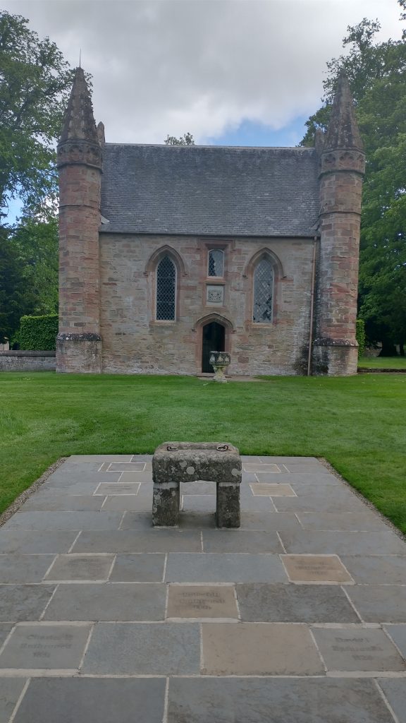
Replica of the Stone of Destiny at Scone Palace, Photo Kevin Flude
A study of the Stone of Destiny, the Stone of Scone, the Coronation Stone, has revealed new information. Firstly, it has some markings which look like three X’s and something like a V – perhaps Roman Numerals or more likely, crosses.
The Stone also revealed traces of copper alloy showing that a metal object had been attached to the Stone for a considerable time. The most obvious suggestion would be a relic associated with a Saint, and a Bell is one possibility.
Traces of gypsum suggested someone sometime made a plaster copy of the stone. No one knows when or why, and it has not been found.
Historic Environment, Scotland has released this fascinating 3-D scan of the stone for the public to view – it is annotated too.
You can read more at the links below, and thank you to Jean Kelly of the Britarch mailing list for alerting me to this.
The Stone has been moved from its permanent home at Edinburgh Castle for the first time since 1996, to be placed under the Coronation Chair for Charles’s May 6 Coronation at Westminster Abbey.
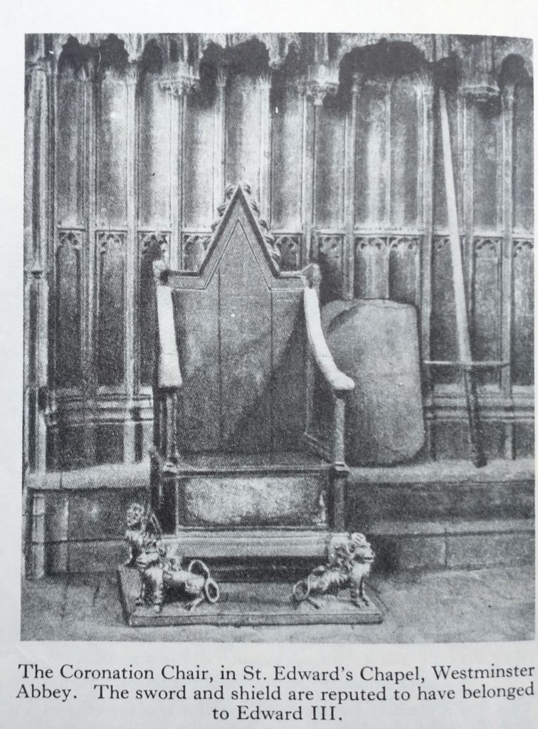
Coronation Chair, with Stone of Scone under the seat.
The Stone was kept at Scone before it was stolen by Edward 1 of England, who placed it under the Coronation Chair, at Westminster, to sanctify English Kings and to make the point that he was the overlord of the Scottish. In the 1950’s Scottish students stole it back, hid it for a few weeks and then left it at Arbroath Abbey. They did this because the so-called Declaration of Arbroath (1320) is a letter to the Pope asking for his endorsement of Scotland’s claim to be independent of England. The Pope agreed.
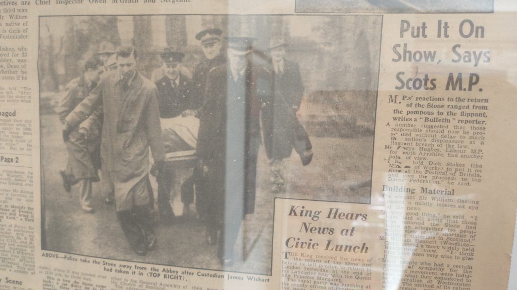
The Stone was recovered from Arbroath taken back to Westminster. The Labour Party under Tony Blair, granted Scotland back their own Parliament and as a symbol of their regained independence, the Stone of Destiny was taken back to Scotland.
Newspaper cutting showing the Stone being taken from Arbroath Abbey
To my mind it should be in Scone, which is where Macbeth and most other Scottish Kings were crowned, but perhaps they thought it should be in the Capital and in the safety of the Castle. At Scone, the Stone was placed on a mound of earth which was said to be made up of the dust from the feet of those attending Coronations symbolising the consent of all of Scotland for the new King.
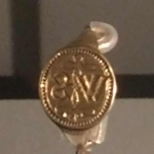
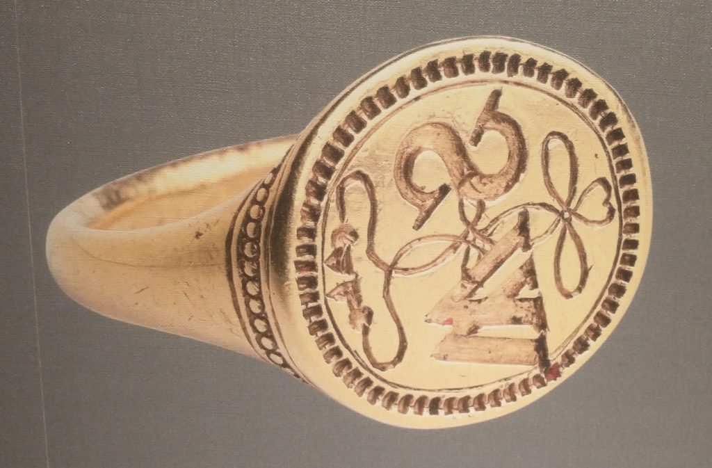
I went to New Place in Stratford-upon-Avon to see the First Folio Exhibition on the anniversary of its publication in 1623. It was a very small exhibition, and, at first sight quite disappointing. Almost everything in it I had seen before. But, I came away quite excited, because it had a much better explanation of the Signet Ring than the one in its previous display.
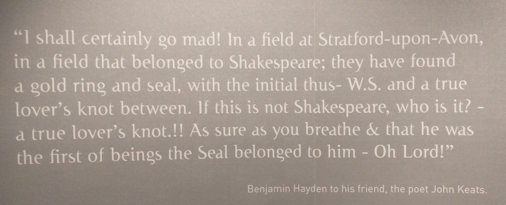
In 1810 someone found this gold ring in field near the Holy Trinity Church where Shakespeare was baptised and buried. It has a lover’s knot and the initials WS. It could ofcourse be anyone’s with those initials. But it certainly excited comment at the time as the display makes clear:
I did not know about the ring until New Place was refurbished a few years ago and the ring went on display. The new display gives more of an explanation as well as the delightful quotation above from Hayden to Keats.
Michael Wood suggested that Shakespeare might have lost the ring on the occassion of his daughter, Judith’s, marriage to Thomas Quiney in February 1616. Shakespeare made his Will a month later, and it is marked by three of his signatures. The Will says ‘whereof I have hereunto put my seale’. The word seale has been crossed out and the word ‘hand’ put in in its stead. So, he was intending to seale his approval of the Will, but changed his mind and put his signature instead? Why? Because he had recently lost his seal ring? Shakespeare died a month or so later.
Photo of the display photo of the Ring that maybe Shakespeare’s
Judith was the twin of Hamnet who died at age 11 and the Church has recently planted a couple of trees as a memorial to the twins, who are not buried, like their older sister, Suzanna, next to their mum and dad by the altar in the Church. Judith’s husband was a bit of a rogue, as he was called to the Bawdy Court and accused of debauchery with a local women who he made pregnant, and who died in childbirth. He is not mentioned in the Will.
But Shakespeare did leave money in his will to buy gold rings for his fellow actors, John Heminges and William Condell, who are buried in St Mary Aldermanbury in London. They outlived Shakespeare and collected his plays together in the First Folio. A Remembrance Ring is also in the display.
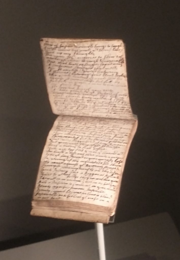
Handwritten notebook written in the 1620s full of quotations from the First Folio
The other main item in the display is this tiny 7.8 cm high notebook in which its unknown owner copied out his favourite quotes from the First Folio. It contains material from all 38 plays, and internal evidence shows it must have been made from the First Folio. It is about the size of the minature books the Brontes made. The tiny writing of the book must have been written with a quill from a small bird.
The display shows that a lot can be made of a few objects, if they are well chosen and with an excellent explanation.
By the way the rings and the Folio are clear evidence that Shakespeare wrote the plays as his friends put together his plays in a volume with introductory information which makes it absolutely clear he wrote them. Also in the Church the memorial to Shakespeare compares him to King Nestor in judgement, Socrates in wisdom, and Virgil in art. Nothing can be clearer, and why people continue to say Shakespeare was simply an actor who copied out the plays is beyond me.
Pylium is a reference to King Nestor of Pylos. Maronem is Virgil. The last line means ‘The earth buries him’ the people mourns him, Olympus posesses him’.
Spring is time for a tansy, so time to bring out again the many stories behind this awesome plant. The tansy not flowers display a classical Fibonacci spiral, which is two counter-rotating logarithmic spirals.
Mrs Grieve in her Modern Herbal repeats the belief that their name derives from the Greek word for immortality ‘Athanaton’. This might be because they grow so well that in some areas they are proscribed they are so prolific. But Tansy was supposed to have been given to Ganymede by Zeus to make him immortal. And, they were used for preserving dead bodies from corruption. So, Tansy was placed in coffins and winding sheets and tansy wreaths placed with the dead.
Its toxicity means that it repels many insects, particularly, flies and ants, and so it was used as a medieval and early modern strewing herb. And yet there are other insects that love Tansy – it seems to have a dark side and a light side.
It was collected in August (along with meadowsweet or elder leaves) and strewn on the floors of houses (and the ‘thresh’ was held in by the threshold). But it was also placed between mattresses to keep away bugs. People rubbed meat with Tansy to keep flies off. It is now used as a natural protection for crops from insects to reduce the amount of artificial pesticides.
It was an important medical and culinary herb, said to be a substitute for nutmeg and cinnamon, and the leaves, shredded, as a flavouring for puddings and omelettes. At Easter ball games a Tansy Cake was the reward for the winners. It was symbolic of the bitter herbs eaten by the Israelites at Passover. Tansy was thought to be a very wholesome ingredient to eat after the sparsity of Lent and Winter, and voiding the body of the worms caused by eating too many fish. It was used for expelling worms from the stomachs of children.
Interestingly it contains thujone, which is also in Wormwood, the other main herb for expelling intestinal worms. Thujone can cause convulsions, liver and brain damage if too much is taken.
In the 14th Century it was used for treating wounds. It was thought to be useful both to induce abortions but also to help women conceive and to prevent miscarriages. Culpepper and Gerard suggests the root was a cure for gout.
Take three pints of Cream, fourteen New-laid-eggs (seven whites put away) one pint of juyce of Spinage, six or seven spoonfuls of juyce of Tansy, a Nutmeg (or two) sliced small, half a pound of Sugar, and a little Salt. Beat all these well together, then fryit in a pan with no more Butter then is necessary. When it is enough, serve it up with juyce of Orange or slices of Limon upon it.
Sir Kenelm Digby was a Catholic and a natural philosopher of some reputation. After his death an employee published his cookery book. His father was executed after the Gunpowder Plot, and he supported Charles 1st but found a way to work with Oliver Cromwell.
He made a great success of his idea of the ‘powder of sympathy’ – 29 editions of his book on the subject were sold. He found the powder in France and it was made with precise ‘astrological’ techniques. The most famous example of a suggested application for the powder was to win the competition for a method of working out longitude (in the 18th Century). Basically, a working method meant knowing the time, normally noon, in two different places. This allowed a triangle to be created between the two points and the Sun which allowed the distance between the two places to be discovered by triangulation. Clocks were not accurate enough (yet) to help so Digby’s famous powder of sympathy was suggested.
This is the method:
A wounded dog would be taken on board a ship, and a bandage from the wound would be left in London. At noon in London it would be sprinkled with the powder of sympathy. The dog on the ship would, perforce, yelp when the powder was administered on the bandage in London and so the Captain would know when it was noon in London! Digby was long dead when the application for the prize money was made and rejected.
‘Longitude’ by Dava Sobel tells the story of the discovery of a clock-based method of calculating longitude.
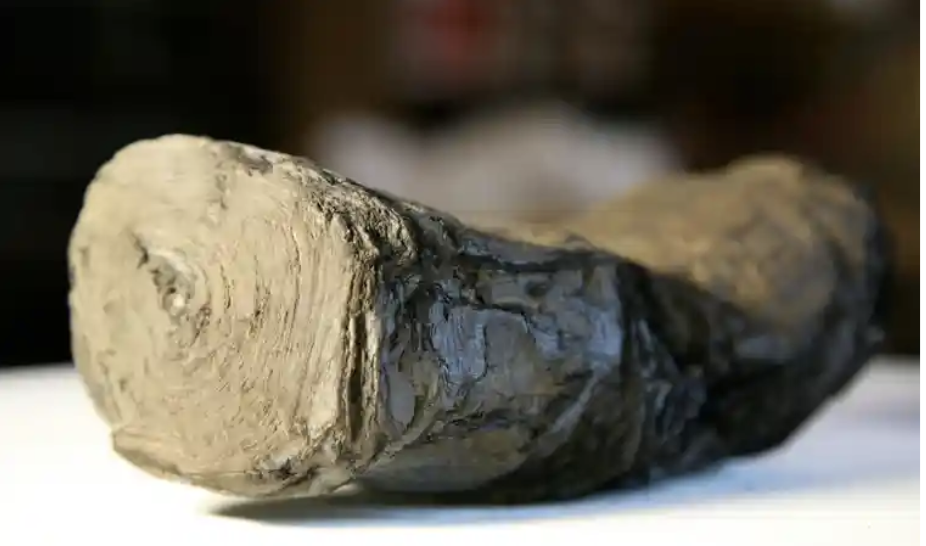
This is one of the most exciting advances I have read about for a long time! A pile of burnt scrolls survive from the Villa dei Papiri, Herculaneum. They are being examined by several teams from American Universities including the University of Michigan, and the University of Kentucky. They are just beginning to read fragments of the texts, using all the scientific techniques they can throw at it including AI. The AI has begun to learn to read fragments of the tightly rolled scroll.
Burnt Scroll
The scroll they are working on appears to be a piece about Alexander the Great and his legacy. It is an unknown text or to put it another way, it is potentially a brand new source of information for this period of time. It has been suggested that it might possibly be a copy of the lost diary of Alexander’s secretary, Eumenos or may have been written by a friend of the general Antigonos. Either way, potentially eye witness accounts. Or not, as perhaps, they may be asking too much from the first investigation. It may be more prosaic. Time will tell.
The implications, however, are so exciting! Just as the amazing excavations at Stonehenge (and indeed in London) have revolutionised our knowledge of these places, so AI could introduce completely new insights into the past. There are many rolls that were burnt in the collection, but now AI is beginning to read them. what insights we might get even from small fragments? One of the scholars involved is particularly excited to imagine the discoveries that could be forthcoming from the Middle East
‘While others would love to see some of the lost work of the ancients, what I’d like to see is evidence of the turmoil that was happening in the first century around the development of Christianity and the Judeo-Christian tradition as it was evolving.’
Brent Seales, University of Kentucky
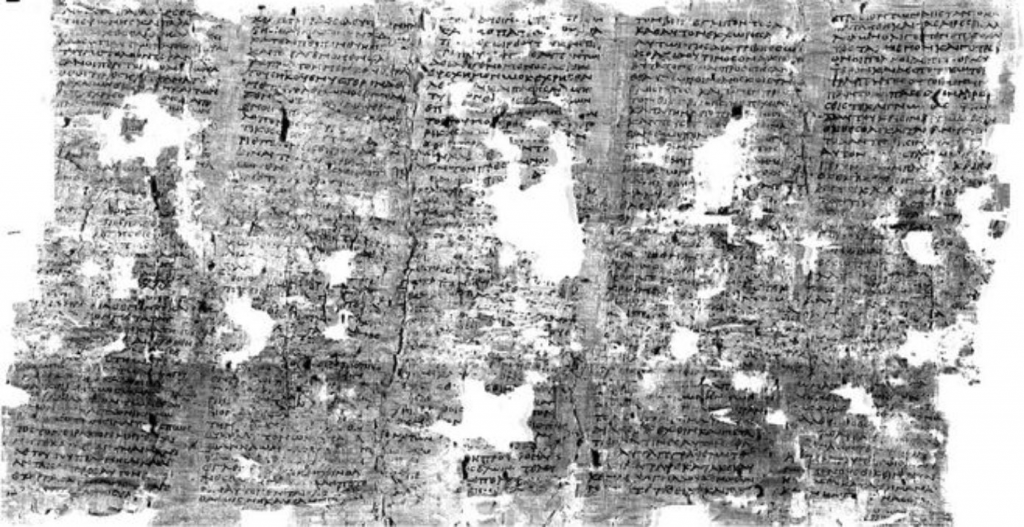
Part of scroll unfolded
But those ‘lost works of the ancients’. There are so many that would rock history: Tacitus’s ‘Annals’ missing missing the last two years of Nero’s reign. Pytheas ‘On the Ocean’ with its first references to Britain in writing. 6 Plays of Aeschylus, 9 Books of Sappho and the list goes on. Have a look at Charlotte Higgins piece in Prospect Magazine for a little more detail.
Another feature of the study is that the teams have released images to the cloud and are encouraging others to ‘have a go’ at reading them. This shows the strides that Citizen Science has made, and how, scientists acknowledge that, in the days of big data, cooperation pays huge dividends.
My source of information is the marvellous The Society of Antiquaries of London Online Newsletter (Salon) which ‘is a fortnightly digest of heritage news‘ and for more information look at Issue 509.
You may have been following my ramblings on my attempts to work out Amsterdam’s history from maps and tramping the streets. But you might want to find out more about the History of Amsterdam from your armchair. So, this is my exploration of virtual Amsterdam. But bear in mind the ideas here can be used in any town exploration.
But if you have only a little time, here are my best tips for exploring Amsterdam online.
First, below is a very good 15 minute introduction to Amsterdam history on YouTube.
Encyclopedia Britannica | Britannica – https://www.britannica.com/place/Amsterdam
I quite often edit Wikipedia pages when I come across entries which are out of date or wrong. The quality of information can be variable but mostly its good. And reading the Amsterdam Page, as long as you are prepared to follow up some of the hypertext links, such as to the ‘Canals of Amsterdam’ or the ‘Defence Line of Amsterdam’ you can get a good idea of the history. But Wikipedia, however great for humanity, is none-the-less aspiring to be an encyclopedia, and not either literature, travel-writing, non-fiction nor entertainment. It is certainly not a virtual tour, and it takes quite a lot of timeto get a good overview of the City and it is not really something I ever do for ‘enjoyment’.
Encyclopedia Britannica has been published exclusively online since 2016 and it is a better read than Wikipedia, less rambling and more to the point. Definitely a better starting point, but still a long read, and, again, something I can’t remember reading with pleasure.
YouTube
There are a number of video lectures/talks/tours on YouTube for free and I will just mention a few – please let me know if you find anything else interesting and I will add it here.
I’ve already linked to the 15 minute ‘A Quick History of Amsterdam (That Dam Guide), which is well put together and gives a good summary. Not enough about the walls in my opinion, and probably a little too much about the major drivers of historical change and not enough about the specific details of what made Amsterdam the town. That is probably asking too much for a 15 minute introduction. And, in effect, this guide is an advert for ‘That Dam Guide’ and the author’s guided virtual tours. He does live streamed 1 hour Amsterdam Tours (none on in March) Very good production values too.
Searching for ‘Amsterdam Virtual Tour’ brings me to the: The Amsterdam Drone Tour which gives a largely drone-eye view of Amsterdam, with slightly annoying music and not enough captions to really feel you are getting to know streets, areas and districts, but it does give an interesting ‘overview’. It is 9 minutes long.
A Free Virtual Tours Amsterdam is an interesting intro to Amsterdam in two 5 minute videos. It does give you some more of, what I would call, ‘structural’ analysis of the history and development of Holland/Amsterdam. It is, to an extent, complimentary to ‘That Dam Guide’. I should not be mentioning it as the ‘Free Walks’ groups are deadly rivals to ‘London Walks’, who I do my walks for. We have a fixed fee for a professional guide, while the Free Walks say they are free but put a lot of pressure on to get customers to pay up a reasonable amount (or so we think!).
Another ‘Tips based’ guide on YouTube is Tim, who gives a 20 minute free walking tour. This one is more of a real virtual walk, as it is a filmed guided walk, with all its imperfections. But, very good in terms of authenticity.
Google Earth
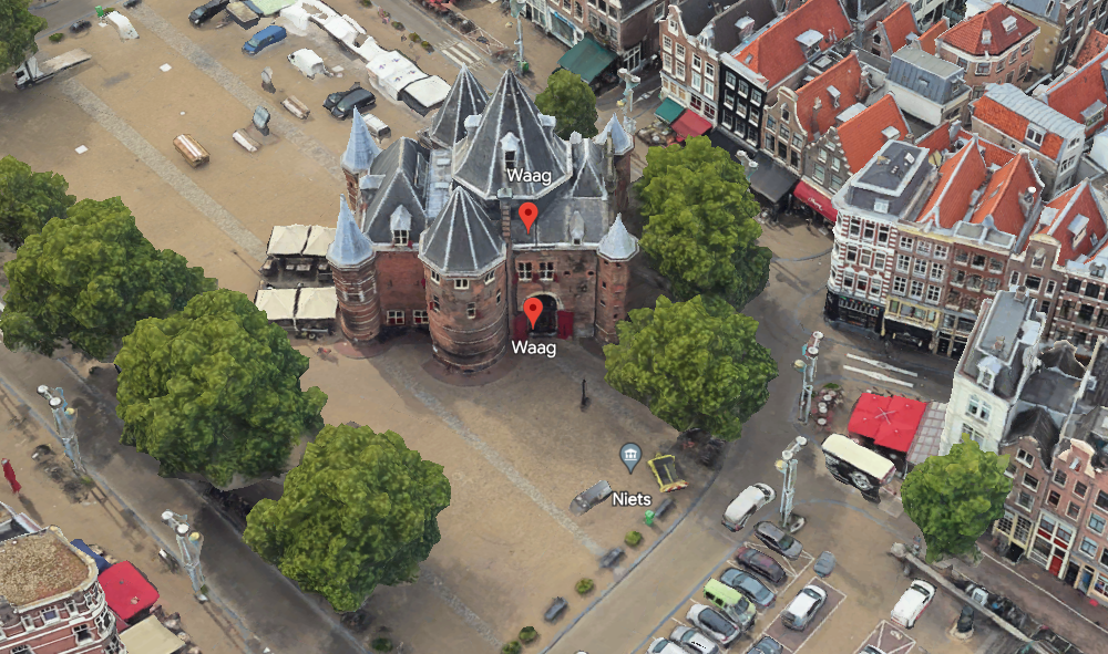
This uses the Google Earth satellite view of Amsterdam, with pins marking many, but by no means all, places of interest. Each place has a little information, and often, a link to Wikipedia. Clicking on the ‘more information’ tab brings up further, and sometimes an extensive number of pictures. There is also a paper aeroplane tab, and this brings up a virtual fly-past which is fun. I was looking for a tab for the Waag, which is one of the remaining gates of old Amsterdam, but I cannot find a tab for it. Nor a search button, which hinders the usefulness of the system. But it is definitely fun!
I have just gone back to Google Earth, found the search icon on the left of the screen, overflown my house, and then searched for the Waag, which I found and here it is! Follow the link to do the fly-past.
Google Earth view of the Waag, City Gate, Dissection Theatre, and now a Restaurant.My house, on google-earth, to the south of the Canal is a strip of Grass, I live at the extreme left of that strip of grass.
I would definitely use this to explore, and, if I were to be giving a guided tour of Amsterdam I would, indeed, use it in advance to consolidate my knowledge. It has the advantage that it brings to your attention things you would otherwise not know about, and gives a really clear idea of what the place is and what its environment looks like. For example it brought to my attention the houseboat museum, which is now on my must-see bucket list, previously unknown to me.
By the way, I found the Google Earth tour on this blog: www.asthebirdfliesblog.com which has other interesting tips for exploring virtual Amsterdam.
Guided Walks Apps
I thought these didn’t really count as they are designed to give a smart-phone based on location walking tour and not an armchair guide. GPSmycity.com is linked to GPS and the user can either access other people’s guided walks, or create their own. I tried it out in Stratford-on-Avon and found it remarkably easy to do. You find the places you want on the tour, and the app ‘sucks in’ the data and pictures from Wikipedia. So within a few minutes you have, a credible, guided tour and a GPS route around the City. In fact, I found it most useful just for creating my own walking routes – much easier than Google, or CityMapper, Just put in the stops and soon your SmartPhone will be dictating your route to you!
But you don’t have to access it via an app, in fact, if you are not going to Amsterdam, its better to visit the web site, and you can go to this link gpsmycity.com, scroll down and you will see a map, and the text for all the stops on the tour. Quite a good introduction, although not inspired. (Its possible you might need to login but I’m not sure as I do have a login.)
Another example is izi-travel, but this provides free and paid for audio guides. Again designed for a smart-phone app to guide around the location, but it can also be accessed on a computer at home. So here is the link to the Amsterdam tour – there are several to choose from.
I would definitely use gpsmycity on tour – I didn’t because I dropped my phone in the oily bilge of my boat, and it went insane for about 2 hours, and reset a lot of my settings, and deleted a few of my apps, including gpsmycity, before deciding to stage a recovery. Izi-travel I have had loaded for several years, and never used, but now listening to it I might have used it like a radio show to introduce me to Amsterdam. I’m also wondering about making my very many guided walks into virtual guided walks on apps like this.
Museum On Line Tours
The Amsterdam Museum should be the museum I would be pointing to for a great on line tour about Amsterdam’s History but it has a temporary Web Site while it works on opening a new Museum. The web has interesting stuff on it, and has the collection online, but nothing that pulls it together like an exhibition, or really gives you much of an introduction to the history of Amsterdam which is very disappointing.
The Van Gogh Museum, by contrast, has an excellent online collection which can be seen, as if a virtual exhibition. But this is much easier for an art museum than a history museum, for two main reasons: the art works are more immediately visually appealing that many objects in Museum Collections which often require context to understand; and art collections are much smaller than history museum collections and so easier to see as a ‘tour’.
Summary
There is nothing to beat walking around a City in the real world. There is nothing, yet, that even comes close to it. Smart Phone tours offer an easy way to tour the physical city, but its difficult to find content on line which provides a really enjoyable armchair online substitute.
The way I explore a City, after finding the walls of course(!), is to read a good guide book. Then buy a good non-fiction history of the city, and search the second hand bookshops for histories/guides/maps and that very special book that noone has heard of and no one knows about which gives unique insights/information that a good guided tour needs. Finally, I try to read a famous novel set in the City, or if in need of light relief, find a local fictional detective.
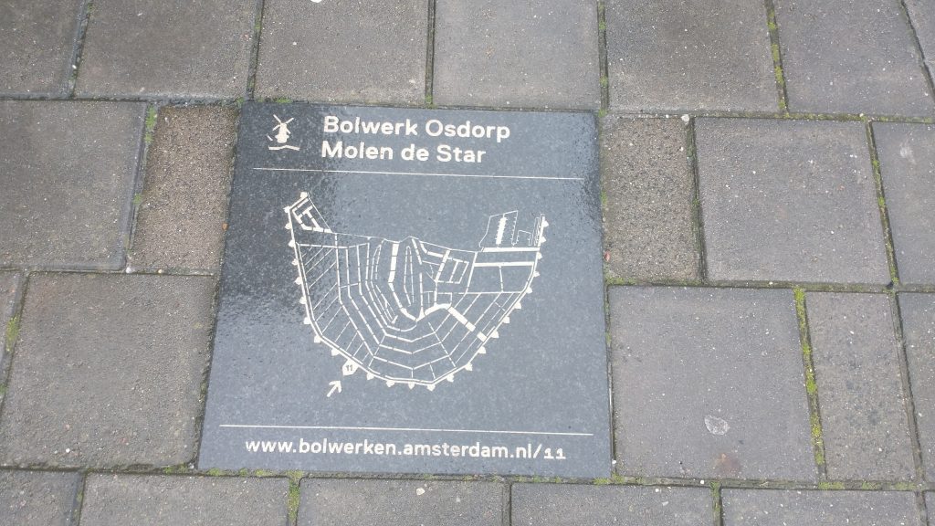
So, I have built up a story of a Medieval City Wall of Amsterdam with a moat around it and the Amstell flowing through the middle. In the 17th Century the defenses are developed and a set of concentric canals are built.
You can see the details in the schematic plan above. Defensive circuit around the outside, concentric circles of canals inside. The first doubt came to my mind when the pilot of the tourist boat we took around the canals said the concentric rings were built up outwards progressively from the 13th Century onwards.
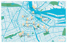
So, this must mean the original circuit was small and the later circuits expanded the size of the City. Just have a look at a modern plan for a moment.
City plan
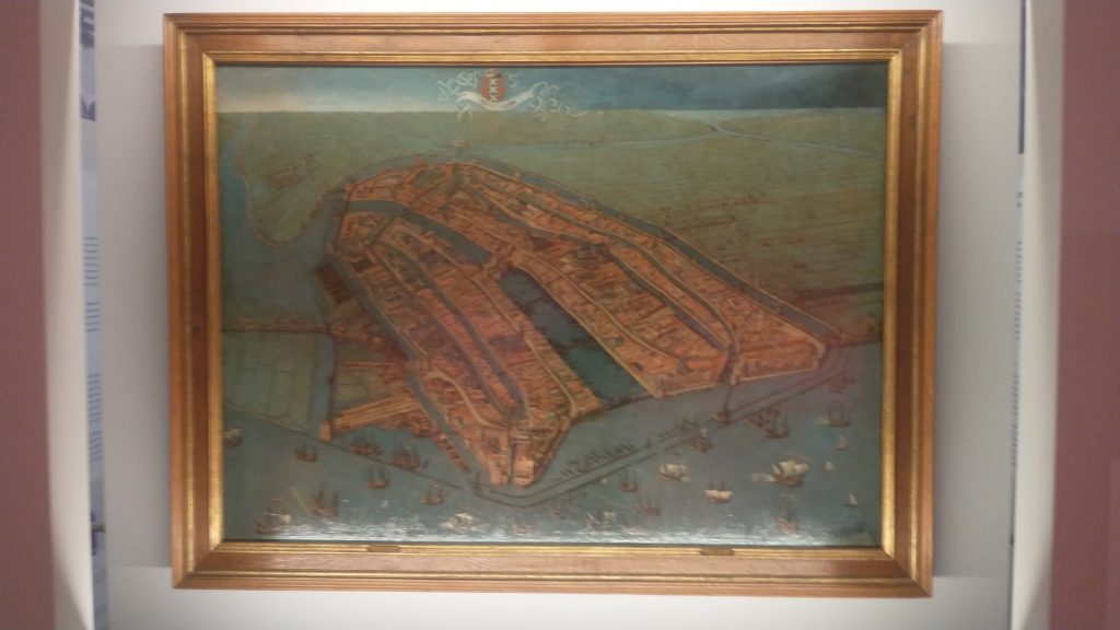
Therefore, the medieval circuit was the inner concentric ring and the latest 17th Century circuit was the outer ring. So at least two different defensive perimeters. Let’s look back at the earliest plan of Amsterdam.
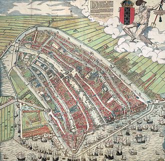
The oldest view of Amsterdam by Cornelius Antonisz 1538
This shows the City wall, the port on the seafront at the bottom of the painting with the River Amstel running through the middle of the City, and canals running parallel. There is a moot running outside the wall circuit. This moat is not, as I previously thought, the outer circuit as shown on the modern plan, or on the grey plaque. It is, in fact, the inner circuit. I’ve just looked it up and the moat is called the Singel, originally called the Stedegracht (“City Canal”).
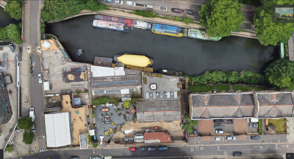
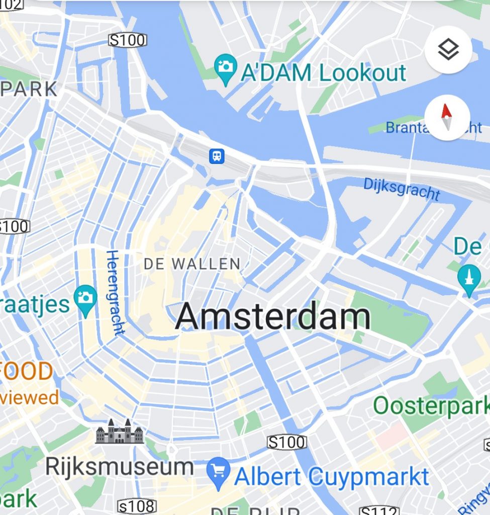
Look at the Google map. The inner blue circuit is the Singel, the original moat and medieval defensive wall. The word Amsterdam is written above where the Singel meets the Amstell. The outer circuit is the 17th Century defensive circuit. You’ll see the icon of Rijksmuseum on this outer canal.
Google Map of the Hiatoric Centre 0f Amsterdarm
Now, a bit of research shows that the Pilot on the boat was repeating an old tale that the canals were progressively expanded from the medieval period onwards. He suggested that as Amsterdam grew it built itself another circuit of canals. But wikipedia assures me this is wrong. What happened was that Amsterdam became so overcrowded in the 17th Century that the authorities had to do something and what they decided to do was to enlarge the City and built a grid of concentric canals linked by linear canals, with an outer circuit of defensive bastions. surrounded by a final concentric canal. The main engine of development was commercial success followed by massive immigration. Its an amazing story of foresight. It meant that Amsterdam’s merchants could all enjoy direct access to goods coming by river and sea, or to shipping if they were exporting.
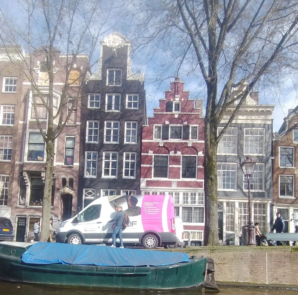
Each merchant had a tall thin warehouse/workshop of 5 to 7 stories high with a gable with a pole built into it for a pulley to lift goods up from the barges moored outside the merchants house. These houses are mostly of brick although the richest have the trappings of classical columns, and staircases leading up to the first floor. And Amsterdam also had the foresight to keep these merchants houses, and not knock them down. So a large percentage of the centrum of the City is still made up of these brick merchants houses. In the prestigious areas they are banks and offices, elsewhere shops, and houses.
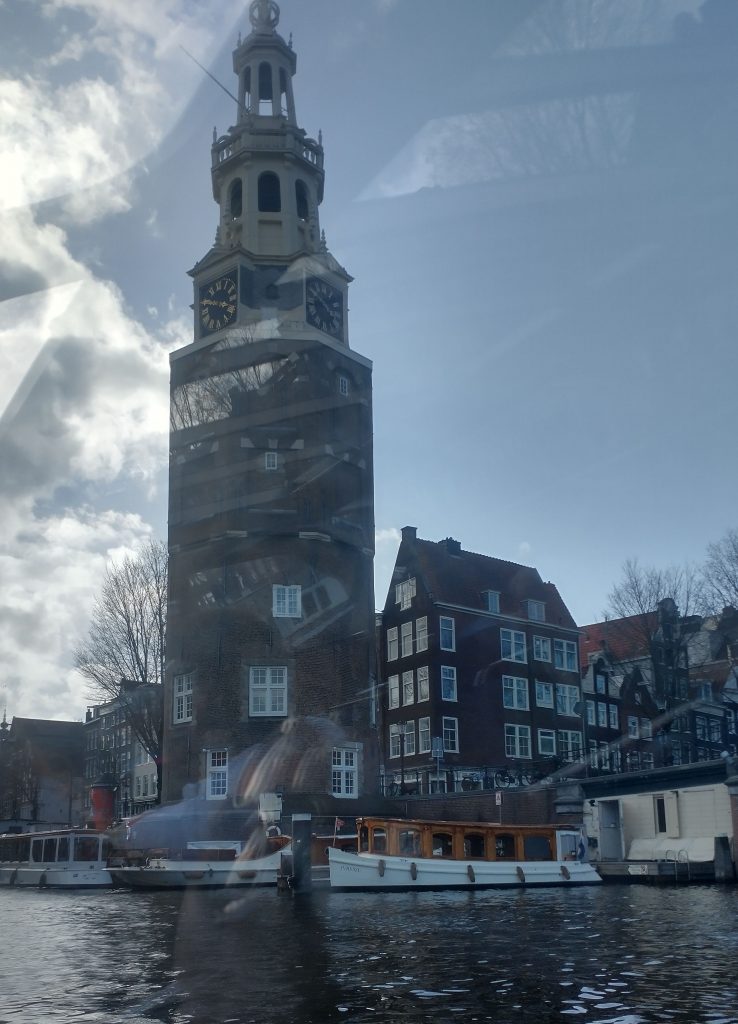
This is a defensive tower on the medieval circuit
Defensive tower on the Medieval Defensive CircuitExamples of Merchante Houses of the 17th/18th Century
I’m not sure if this insight into my working process is enjoyable or not. Its something I have always done because for many years I have enjoyed leading guided walks, and cultural study tours around historic towns in the UK and Europe. In order to feel confident about the tour I have to feel I know the City, and how it articulates, and developed through time. Often it isn’t just a case of reading a guide book or wikipedia. It needs quite a lot of work to understand what is happening are what are the structural elements that led to the City as we see it today. I doubt for example, I would have realised that the Pilot was wrong, had I not had an image of the 16th Century City in my mind to compare with what he was saying.
Another 16th Century view of the original core of the town (by Cornelis Antonisz