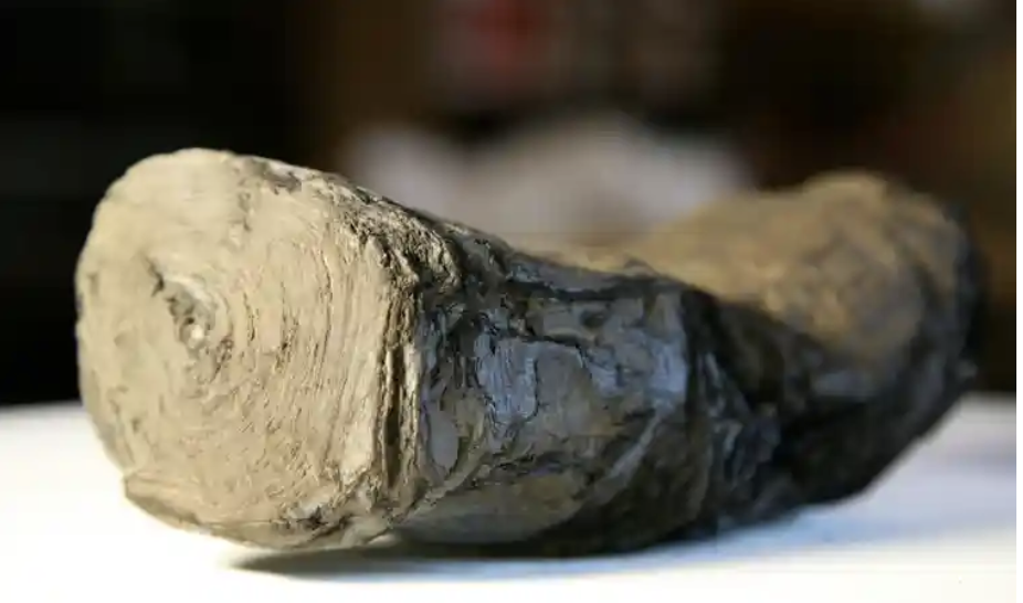
This is one of the most exciting advances I have read about for a long time! A pile of burnt scrolls survive from the Villa dei Papiri, Herculaneum. They are being examined by several teams from American Universities including the University of Michigan, and the University of Kentucky. They are just beginning to read fragments of the texts, using all the scientific techniques they can throw at it including AI. The AI has begun to learn to read fragments of the tightly rolled scroll.
Burnt Scroll
The scroll they are working on appears to be a piece about Alexander the Great and his legacy. It is an unknown text or to put it another way, it is potentially a brand new source of information for this period of time. It has been suggested that it might possibly be a copy of the lost diary of Alexander’s secretary, Eumenos or may have been written by a friend of the general Antigonos. Either way, potentially eye witness accounts. Or not, as perhaps, they may be asking too much from the first investigation. It may be more prosaic. Time will tell.
The implications, however, are so exciting! Just as the amazing excavations at Stonehenge (and indeed in London) have revolutionised our knowledge of these places, so AI could introduce completely new insights into the past. There are many rolls that were burnt in the collection, but now AI is beginning to read them. what insights we might get even from small fragments? One of the scholars involved is particularly excited to imagine the discoveries that could be forthcoming from the Middle East
‘While others would love to see some of the lost work of the ancients, what I’d like to see is evidence of the turmoil that was happening in the first century around the development of Christianity and the Judeo-Christian tradition as it was evolving.’
Brent Seales, University of Kentucky
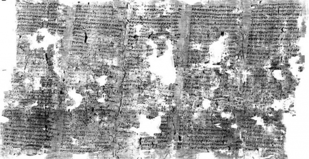
Part of scroll unfolded
But those ‘lost works of the ancients’. There are so many that would rock history: Tacitus’s ‘Annals’ missing missing the last two years of Nero’s reign. Pytheas ‘On the Ocean’ with its first references to Britain in writing. 6 Plays of Aeschylus, 9 Books of Sappho and the list goes on. Have a look at Charlotte Higgins piece in Prospect Magazine for a little more detail.
Another feature of the study is that the teams have released images to the cloud and are encouraging others to ‘have a go’ at reading them. This shows the strides that Citizen Science has made, and how, scientists acknowledge that, in the days of big data, cooperation pays huge dividends.
My source of information is the marvellous The Society of Antiquaries of London Online Newsletter (Salon) which ‘is a fortnightly digest of heritage news‘ and for more information look at Issue 509.
You may have been following my ramblings on my attempts to work out Amsterdam’s history from maps and tramping the streets. But you might want to find out more about the History of Amsterdam from your armchair. So, this is my exploration of virtual Amsterdam. But bear in mind the ideas here can be used in any town exploration.
But if you have only a little time, here are my best tips for exploring Amsterdam online.
First, below is a very good 15 minute introduction to Amsterdam history on YouTube.
Encyclopedia Britannica | Britannica – https://www.britannica.com/place/Amsterdam
I quite often edit Wikipedia pages when I come across entries which are out of date or wrong. The quality of information can be variable but mostly its good. And reading the Amsterdam Page, as long as you are prepared to follow up some of the hypertext links, such as to the ‘Canals of Amsterdam’ or the ‘Defence Line of Amsterdam’ you can get a good idea of the history. But Wikipedia, however great for humanity, is none-the-less aspiring to be an encyclopedia, and not either literature, travel-writing, non-fiction nor entertainment. It is certainly not a virtual tour, and it takes quite a lot of timeto get a good overview of the City and it is not really something I ever do for ‘enjoyment’.
Encyclopedia Britannica has been published exclusively online since 2016 and it is a better read than Wikipedia, less rambling and more to the point. Definitely a better starting point, but still a long read, and, again, something I can’t remember reading with pleasure.
YouTube
There are a number of video lectures/talks/tours on YouTube for free and I will just mention a few – please let me know if you find anything else interesting and I will add it here.
I’ve already linked to the 15 minute ‘A Quick History of Amsterdam (That Dam Guide), which is well put together and gives a good summary. Not enough about the walls in my opinion, and probably a little too much about the major drivers of historical change and not enough about the specific details of what made Amsterdam the town. That is probably asking too much for a 15 minute introduction. And, in effect, this guide is an advert for ‘That Dam Guide’ and the author’s guided virtual tours. He does live streamed 1 hour Amsterdam Tours (none on in March) Very good production values too.
Searching for ‘Amsterdam Virtual Tour’ brings me to the: The Amsterdam Drone Tour which gives a largely drone-eye view of Amsterdam, with slightly annoying music and not enough captions to really feel you are getting to know streets, areas and districts, but it does give an interesting ‘overview’. It is 9 minutes long.
A Free Virtual Tours Amsterdam is an interesting intro to Amsterdam in two 5 minute videos. It does give you some more of, what I would call, ‘structural’ analysis of the history and development of Holland/Amsterdam. It is, to an extent, complimentary to ‘That Dam Guide’. I should not be mentioning it as the ‘Free Walks’ groups are deadly rivals to ‘London Walks’, who I do my walks for. We have a fixed fee for a professional guide, while the Free Walks say they are free but put a lot of pressure on to get customers to pay up a reasonable amount (or so we think!).
Another ‘Tips based’ guide on YouTube is Tim, who gives a 20 minute free walking tour. This one is more of a real virtual walk, as it is a filmed guided walk, with all its imperfections. But, very good in terms of authenticity.
Google Earth
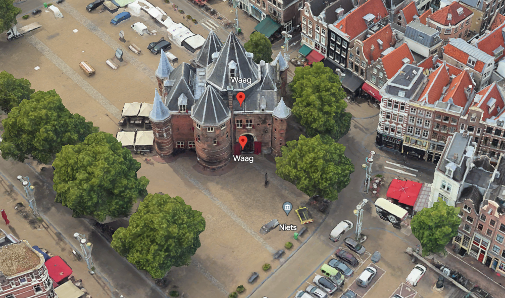
This uses the Google Earth satellite view of Amsterdam, with pins marking many, but by no means all, places of interest. Each place has a little information, and often, a link to Wikipedia. Clicking on the ‘more information’ tab brings up further, and sometimes an extensive number of pictures. There is also a paper aeroplane tab, and this brings up a virtual fly-past which is fun. I was looking for a tab for the Waag, which is one of the remaining gates of old Amsterdam, but I cannot find a tab for it. Nor a search button, which hinders the usefulness of the system. But it is definitely fun!
I have just gone back to Google Earth, found the search icon on the left of the screen, overflown my house, and then searched for the Waag, which I found and here it is! Follow the link to do the fly-past.
Google Earth view of the Waag, City Gate, Dissection Theatre, and now a Restaurant.My house, on google-earth, to the south of the Canal is a strip of Grass, I live at the extreme left of that strip of grass.
I would definitely use this to explore, and, if I were to be giving a guided tour of Amsterdam I would, indeed, use it in advance to consolidate my knowledge. It has the advantage that it brings to your attention things you would otherwise not know about, and gives a really clear idea of what the place is and what its environment looks like. For example it brought to my attention the houseboat museum, which is now on my must-see bucket list, previously unknown to me.
By the way, I found the Google Earth tour on this blog: www.asthebirdfliesblog.com which has other interesting tips for exploring virtual Amsterdam.
Guided Walks Apps
I thought these didn’t really count as they are designed to give a smart-phone based on location walking tour and not an armchair guide. GPSmycity.com is linked to GPS and the user can either access other people’s guided walks, or create their own. I tried it out in Stratford-on-Avon and found it remarkably easy to do. You find the places you want on the tour, and the app ‘sucks in’ the data and pictures from Wikipedia. So within a few minutes you have, a credible, guided tour and a GPS route around the City. In fact, I found it most useful just for creating my own walking routes – much easier than Google, or CityMapper, Just put in the stops and soon your SmartPhone will be dictating your route to you!
But you don’t have to access it via an app, in fact, if you are not going to Amsterdam, its better to visit the web site, and you can go to this link gpsmycity.com, scroll down and you will see a map, and the text for all the stops on the tour. Quite a good introduction, although not inspired. (Its possible you might need to login but I’m not sure as I do have a login.)
Another example is izi-travel, but this provides free and paid for audio guides. Again designed for a smart-phone app to guide around the location, but it can also be accessed on a computer at home. So here is the link to the Amsterdam tour – there are several to choose from.
I would definitely use gpsmycity on tour – I didn’t because I dropped my phone in the oily bilge of my boat, and it went insane for about 2 hours, and reset a lot of my settings, and deleted a few of my apps, including gpsmycity, before deciding to stage a recovery. Izi-travel I have had loaded for several years, and never used, but now listening to it I might have used it like a radio show to introduce me to Amsterdam. I’m also wondering about making my very many guided walks into virtual guided walks on apps like this.
Museum On Line Tours
The Amsterdam Museum should be the museum I would be pointing to for a great on line tour about Amsterdam’s History but it has a temporary Web Site while it works on opening a new Museum. The web has interesting stuff on it, and has the collection online, but nothing that pulls it together like an exhibition, or really gives you much of an introduction to the history of Amsterdam which is very disappointing.
The Van Gogh Museum, by contrast, has an excellent online collection which can be seen, as if a virtual exhibition. But this is much easier for an art museum than a history museum, for two main reasons: the art works are more immediately visually appealing that many objects in Museum Collections which often require context to understand; and art collections are much smaller than history museum collections and so easier to see as a ‘tour’.
Summary
There is nothing to beat walking around a City in the real world. There is nothing, yet, that even comes close to it. Smart Phone tours offer an easy way to tour the physical city, but its difficult to find content on line which provides a really enjoyable armchair online substitute.
The way I explore a City, after finding the walls of course(!), is to read a good guide book. Then buy a good non-fiction history of the city, and search the second hand bookshops for histories/guides/maps and that very special book that noone has heard of and no one knows about which gives unique insights/information that a good guided tour needs. Finally, I try to read a famous novel set in the City, or if in need of light relief, find a local fictional detective.
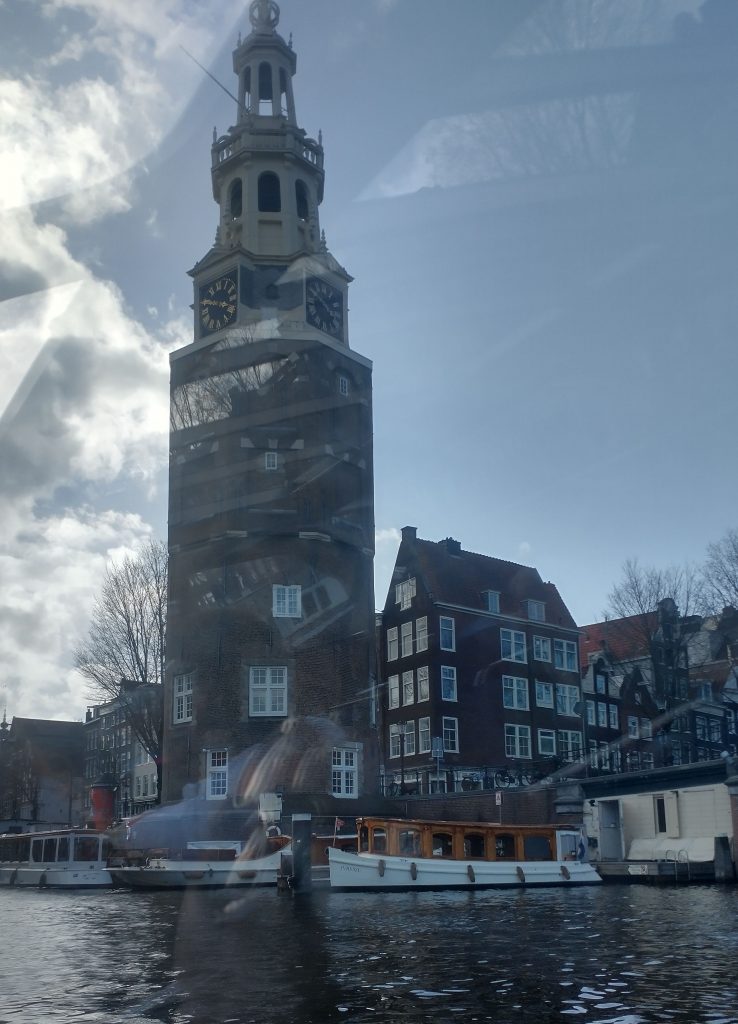
So, I have built up a story of a Medieval City Wall of Amsterdam with a moat around it and the Amstell flowing through the middle. In the 17th Century the defenses are developed and a set of concentric canals are built.
You can see the details in the schematic plan above. Defensive circuit around the outside, concentric circles of canals inside. The first doubt came to my mind when the pilot of the tourist boat we took around the canals said the concentric rings were built up outwards progressively from the 13th Century onwards.
So, this must mean the original circuit was small and the later circuits expanded the size of the City. Just have a look at a modern plan for a moment.
City plan
Therefore, the medieval circuit was the inner concentric ring and the latest 17th Century circuit was the outer ring. So at least two different defensive perimeters. Let’s look back at the earliest plan of Amsterdam.
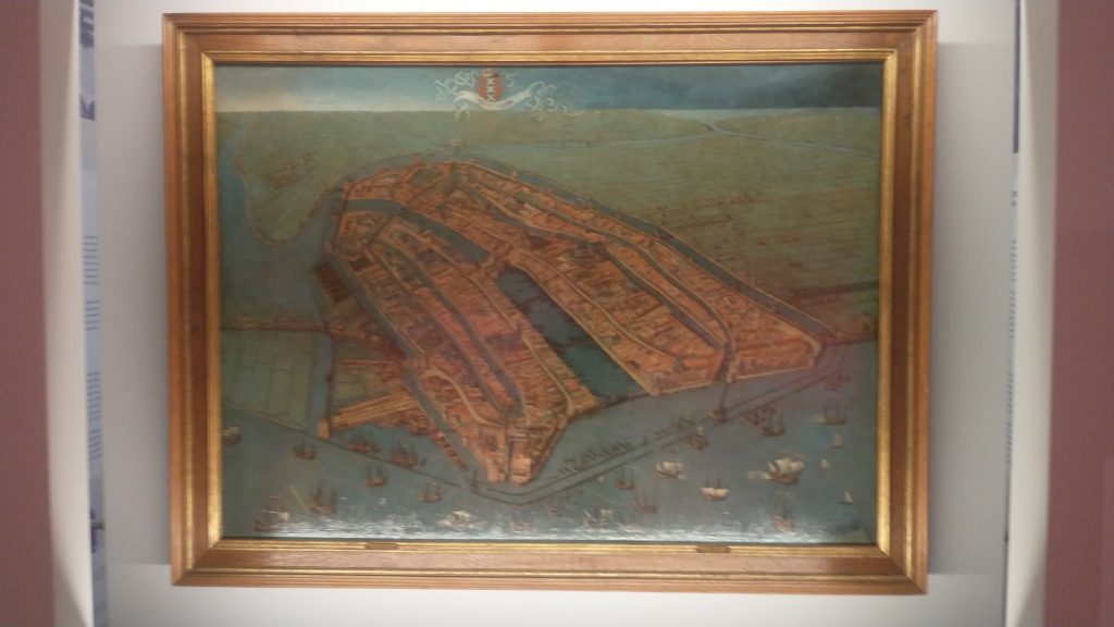
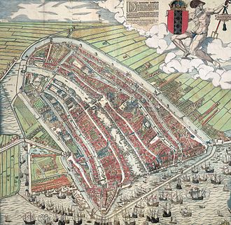
The oldest view of Amsterdam by Cornelius Antonisz 1538
This shows the City wall, the port on the seafront at the bottom of the painting with the River Amstel running through the middle of the City, and canals running parallel. There is a moot running outside the wall circuit. This moat is not, as I previously thought, the outer circuit as shown on the modern plan, or on the grey plaque. It is, in fact, the inner circuit. I’ve just looked it up and the moat is called the Singel, originally called the Stedegracht (“City Canal”).
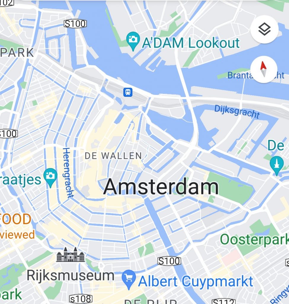
Look at the Google map. The inner blue circuit is the Singel, the original moat and medieval defensive wall. The word Amsterdam is written above where the Singel meets the Amstell. The outer circuit is the 17th Century defensive circuit. You’ll see the icon of Rijksmuseum on this outer canal.
Google Map of the Hiatoric Centre 0f Amsterdarm
Now, a bit of research shows that the Pilot on the boat was repeating an old tale that the canals were progressively expanded from the medieval period onwards. He suggested that as Amsterdam grew it built itself another circuit of canals. But wikipedia assures me this is wrong. What happened was that Amsterdam became so overcrowded in the 17th Century that the authorities had to do something and what they decided to do was to enlarge the City and built a grid of concentric canals linked by linear canals, with an outer circuit of defensive bastions. surrounded by a final concentric canal. The main engine of development was commercial success followed by massive immigration. Its an amazing story of foresight. It meant that Amsterdam’s merchants could all enjoy direct access to goods coming by river and sea, or to shipping if they were exporting.
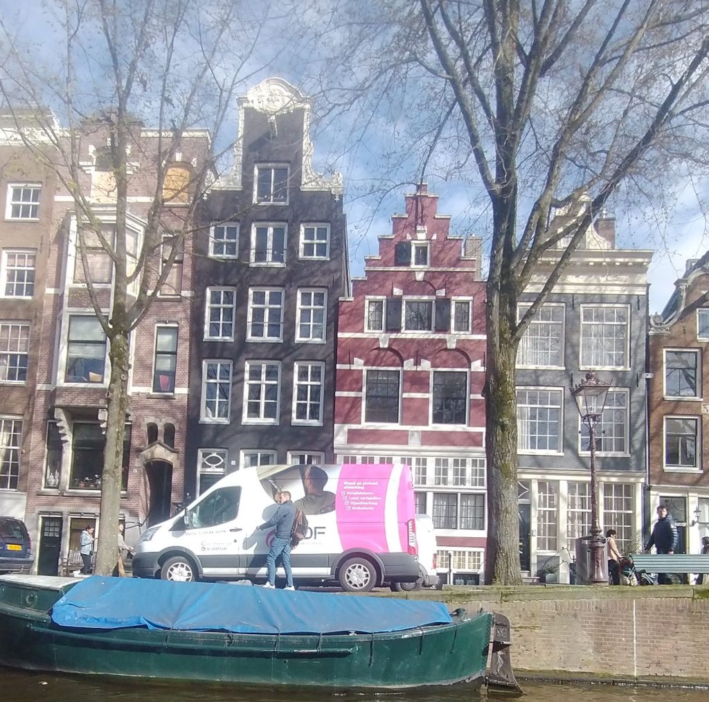
Each merchant had a tall thin warehouse/workshop of 5 to 7 stories high with a gable with a pole built into it for a pulley to lift goods up from the barges moored outside the merchants house. These houses are mostly of brick although the richest have the trappings of classical columns, and staircases leading up to the first floor. And Amsterdam also had the foresight to keep these merchants houses, and not knock them down. So a large percentage of the centrum of the City is still made up of these brick merchants houses. In the prestigious areas they are banks and offices, elsewhere shops, and houses.
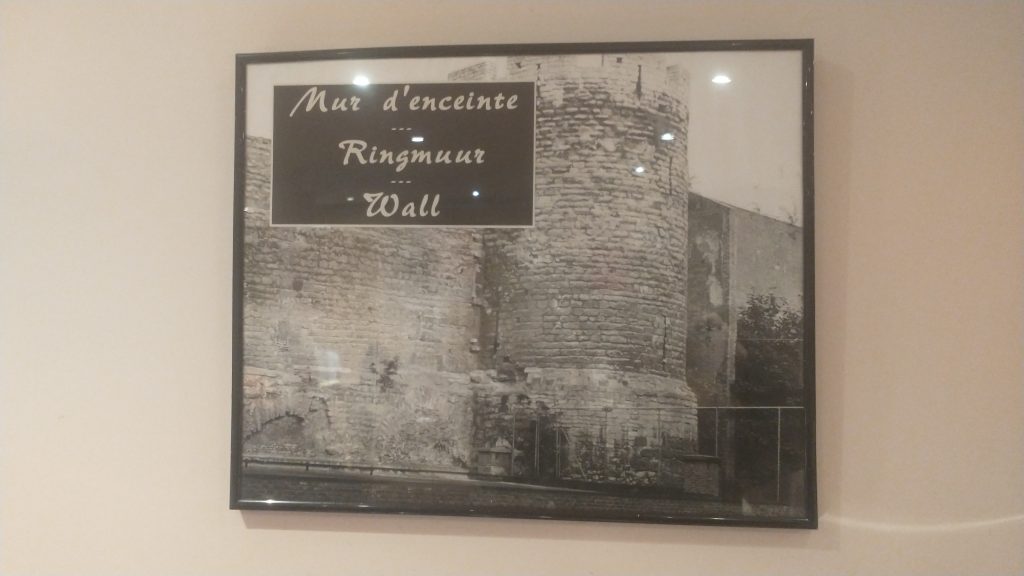
This is a defensive tower on the medieval circuit
Defensive tower on the Medieval Defensive CircuitExamples of Merchante Houses of the 17th/18th Century
I’m not sure if this insight into my working process is enjoyable or not. Its something I have always done because for many years I have enjoyed leading guided walks, and cultural study tours around historic towns in the UK and Europe. In order to feel confident about the tour I have to feel I know the City, and how it articulates, and developed through time. Often it isn’t just a case of reading a guide book or wikipedia. It needs quite a lot of work to understand what is happening are what are the structural elements that led to the City as we see it today. I doubt for example, I would have realised that the Pilot was wrong, had I not had an image of the 16th Century City in my mind to compare with what he was saying.
Another 16th Century view of the original core of the town (by Cornelis Antonisz
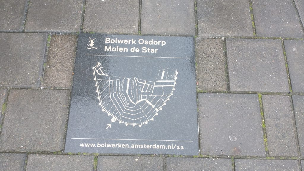
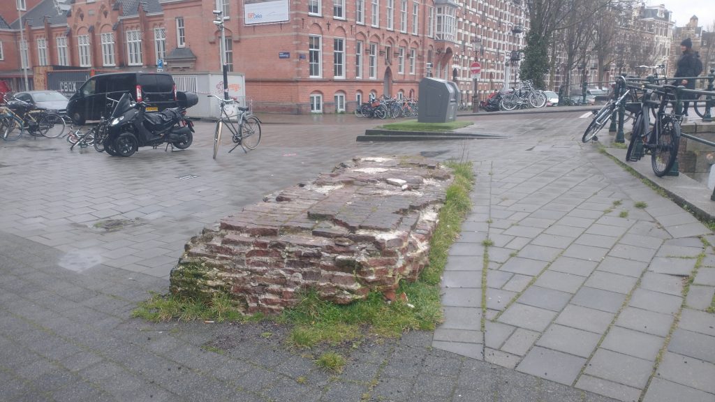
Oh! A glorious find! As I said yesterday, I wasn’t sure there was going to be a wall. But I headed towards the outer of the concentric rings of canals, thinking this is where a defense would be. I almost went straight to the centre but decided I had to give it a try so walked around the inner side of the outer canal. And almost immediately I found this slab of ruin.
The Wall! I thought but was it? And there was a panel with a plan.
Plan of Amsterdam Wall Circuit
The panel links to this Dutch language site which seems to say in 1663 Amsterdam was given a 5 metre high City Wall. It talks about 5 sided ‘bolwerken’ which are bastions designed to withstand cannon fire. And this bit of the wall is near the Osdorp bolwerk.
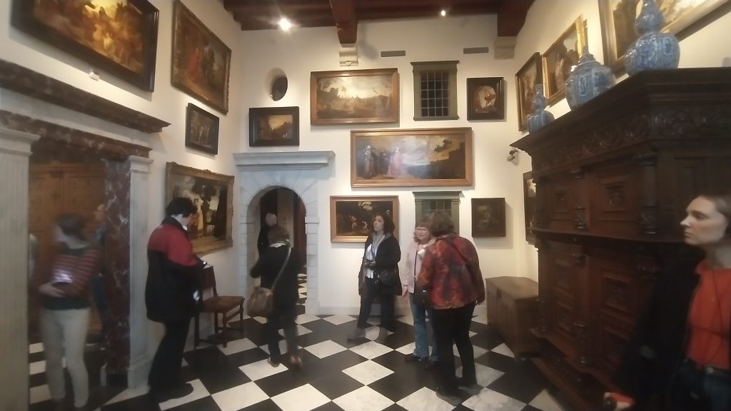
I then met my daughter and we went to the Rembrandt House which was interesting but very heavily reconstructed and in part difficult to know what was original and what a reconstruction.
Rembrandt House, Amsterdam. Photo K.Flude
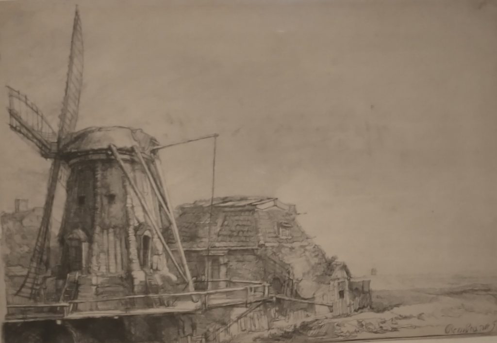
In the display was a Rembrandt Etching which features a section of the City Wall and a Windmill. It is dated to 1641 and so it suggests the 1663 date is for the bolwerken not the wall circuit as such.
The Windmill Rembrandt 1641
The mill was called the Little Stink Mill because it was used in the smelly process of making chamois leather.
There was a plan of the city in Rembrandt’s day but difficult to photo. Our next stop was the Amsterdam Museum which I had insisted we visited to find out information about the history of the City
The oldest view of Amsterdam by Cornelius Antonisz 1538
This shows the City wall with bastions, the port on the seafront at the bottom of the painting with the River Amstel running through the middle of the City, and canals running parallel. There is a moat running outside the wall circuit. What is missing is the concentric ring of canals which now exist inside the wall circuit.
Just to remind you of the current city plan.
City plan
This needs to be turned upside down to match the 16th Century view. A panel in the museum’s notes that Amsterdam is first documented in the late Thirteenth Century. The Protestant Netherlands broke away from the Catholic Hapsburghs in the 16th Century. I’m guessing the walls were built in the late 15th or early 16th Century as the one section I’ve seen is of brick.
So, now I’ve been doing a little research after returning from a visit to the sobering Anne Frank Museum – please remember to challenge prejudice whenever it raises its ugly head. Amsterdam was able to develop into a major town, when a flood turned the shallow river Ij into a wide waterway that linked the Amstel River to the Zuiderzee and the Ijessel in the 12th Century. This gave access to the sea and to the Rhine. It allowed the draining of the banks of the Amstel and with the building of a dam, gave birth to Amsterdam, the Dam on the River Amstel,
In the medieval period the walls were built and bastions added in the 17th Century. In the 17th Century the concentric canal circuits were built and every area given its canal frontage. Virtually all the buildings on the canals have bars protruding from the gable from which to mount a pulley to transfer goods from barge to warehouse, or vice versa,
Between 1880 and 1920 an amazing new defensive circuit was constructed around Amsterdam, which depended up a shallow flooding of the land. But it soon became obelete but is now a Unesco World Heritage Site.
Oh, and to add to what I said, yesterday, the world’s first Stock Exchange was built in Amsterdam in 1602, the same year the Dutch East India company was founded.
It’s a great City, with lots to enjoy, Big enough to be exciting, small enough to be manageable. Full of cyclists on tall upright bikes, chatting to each other as they cycle. I have seen a lot of cyclists riding with their hands in their pockets or holding an umbrella, and it is the first City I have been terrified of crossing the road because of the bikes who seem to ignore pedestrians and expect them to get out of the way; and the trams that hurtle along.
eBay advert screenshot for Old Moore’s Almanac 2024
This week I received my copy of Old Moore’s Almanac. This is probably the best known Almanac in the Uk. It follows the format of Alamancs which have been published since the medieval period as I discussed in an earlier post about the Kalendar of Shepherds of the 15th Century. Almanacs became the third most popular book published in London.
Old Moore’s, which claims ancestry back to 1697, begins with a large tranche of predictions both for the world and for celebrities, based on astrology. 2024, Frances Moore says, is the ‘Year of Hope’. He says, ‘we may have a good time, [but] a severe money problem from elsewhere may surface to worry us’. Hedging his bets or what?!
He predicts astonishing advances in technology, and thinks that Britain is in a good place to profit from these advances in healthcare, IT, and Robotics.
We need good, old-fashioned leadership to get through challenging times, with Pluto in Aquarius and Saturn through Pisces, we should be steered to ‘safe management.’
Wokery will lead us down a spiral to weakness. However, the Tories will remain disorganised with the country receptive to caring Socialism, with an upsurge in local power. The UK will become a more caring society.
Old Moore hints that Putin might be indicted. The US will have deep financial and social problems. The election might be close, but he also suggests Trump’s support might be on the wane.
There is a page for each month, noting the calendar events such as Epiphany, Burns Night, Australia Day, and other days filled with very random notable events chosen to represent that day through history- 2nd Jan Conquest of Granada 1462. 9th Jan Duchess of Cambridge b. 1982, 13th Jan Trump impeached 2021 etc. It also gives a forecast for the Month. January is likely to see constitutional change, Old Moore predicts which seems very unlikely.
Next are columns for Sun rise and set, high water at London Bridge, moon at London. And a weather column. (Early cold spell followed by normal rainy pattern), which isn’t wrong yet.
It has pages of predictions for celebrities such as King Charles III, which suggests ‘communication problems’ in the family. Who could have guessed that! Anton Du Beke, Adele. Zelenskyy, whose entry suggests success will be achieved only by diplomacy; otherwise the stubbornness predicted by the stars will lead to a long stalemate.
Then there are charts for each star sign. Towards the back are astrological help for winning on Horse Racing, Greyhound Racing, Football pools, Bingo, Lottery, Lucky Lotto, Euro Millions and pages for sowing and planting times for gardening by the moon, and a Guide for Anglers.
£5.41 good value, or is it just cheap? It was £3.50 in 2022.
I’ve relieved of the necessity to search for the Town Walls of Amsterdam without prior research by the fact that I am here to see my daughter who has recently broken her ankle, so she has an excuse for refusing to go on forced forced marches around the City.
I haven’t yet had a good look at a map, but the pattern of Canals circuling the centre is amazing and it seems possible there was no need for walls, when the centre is protected by so many rings of water.
I don’t know much about Amsterdam, but it reminds me of the surprising fact that Holland was a major power in the 17th/18th Century. I discovered this on a visit to Kerala in India where I realised that Portugal had a vast empire which was largely taken over by the Dutch in the 17th Century and then taken over by the British in the 18th Century.
It was one of the major pivots in world history. These three countries were small peripheral seafaring nations of no great importance in Europe until the Age of Discovery. Portugal set up trading systems (perhaps rather systems of exploitation) first down the coast of Africa and then to India and beyond. The Dutch then took over the trading stations and took control of the spice routes. Then the British took over.
Previously the spice routes from the East came through Egypt, Greece, Rome, Carthage and later the Ottoman and the Venetian Empires. This made the Mediterranean the richest place in Europe, both north and southern coasts.
The new ocean routes led to a major shift in power from the Mediterranean to the North Sea, leading to the current situation where the Mediterranean is no longer the centre of the world. Greece, Southern Italy, North Africa now under performing economies. A Roman would find this hard to believe.
Portugal, then Holland followed by Britain rose to the status of world power which would, itself, have been inconceivable before the 16th Century.
Holland was in the perfect geographic position astride the trade routes that lead to the heart of Europe. The entry point was the major river systems around the Rhine/Danube axis including the Rhine, the Scheldt, the Waal, and the Amstel. Antwerp, Rotterdam and Amsterdam developed from regional trading towns to global Cities. They spawned a self confident set of merchants who set the foundations of modern capitalism with foundations in spices and slaves.
Central to this was the Dutch East India Company. The first organisation in Europe where an investor only risked their investment rather than the shirt off their back in the event of bankruptcy. This let the shackles off investment, took money out of gold in the bank vaults and multiplied it around the economy.
But not only did it take away the risks of the consequences of investment the Dutch East India Company, set up in Amsterdam in 1602, was given quasi state power, with the ability to fight wars and impose laws on subject populations. This template was copied by the British East India Company which conquered and ran India, setting the seal for the British Empire and Capitalism.
360 degree Image of the Herb Garret (4th December 2000) at the Old Operating Theatre Museum. Click on the VR label to go full screen, and use the mouse to navigate.
Digital Heritage Is a subject I had a very early interest in. My, very minor claim to fame, is that I set up the Museum of London’s and the Victoria and Albert’s first computer systems. I then co-authored one of the earliest hyperlinked digital histories (on the history of London), and set up the first web sites for various museums and organisations such as the Old Operating Theatre Museum, Brunel Engine House, Garden History Museum, Royal Bethlem Museum etc..
But that was a long time ago so long that most of the Museums have changed their names! Despite the desire to do so, I have not had the time to keep up with developments.
So, I’m going to spend a little time investigating online heritage sites, and at the same time, maybe, look back at my part in the history of digital heritage.
Firstly, the principles of the study. Early on I came to the conclusion that the Internet should allow access to Museums for all those people who could not afford, or did not have the time, to visit in person. So, I’m looking for online/virtual visits that have something about them almost as good as a physical visit. Secondly, I’m looking for online exhibitions that provide an enjoyable experience that works in a similar way to a real exhibition. This means for me that the technology does not get in the way, and is not too complex to access and use. I also have an interested in digital guided walking tours.
I must admit that 40 years after I began to see the potential in digital I rarely see virtual visits or exhibitions that I want to spend time with. When I use websites for data and information, which I do all the time. I search, I find, I read but I don’t often linger for pleasure and. I rarely go back.
Yes we have Virtual Reality, Augmented Reality and the Metaverse, but they don’t really impact positively on my experience of heritage, history and museums. This might well be because I haven’t looked very hard, or spent much time on the subject in recent years, or because I don’t enjoy digital experiences that much, But, I’m going to have a good look around to see what is on offer, and I hope you will join me.
My starting point is the Old Operating Theatre Museum web site. I was in charge of the Museum for 30 years from the mid 80s onwards. In the early days of my management of the Museum I set up a very early web site designed to give those who could not visit a real idea of the Museum. This was achieved by the usual set of information pages but also with 360 degree annotated panoramic photos of the museum spaces linked together. This gave a simple and informative tour of the museum. which was easy to use, did not take long to see and did not depend on complicated technology on the part of the user. Later we added an online database of the collection to give access to the collection.
Thanks to the Wayback Machine – which is an amazing internet archive, no the internet archive, which archives old web sites, I have been able to retrieve a version of the site, dated to 2000AD so you can have a look at it. As you will see below it is very wordy but I think a really nice design by Highway 57 and Chris Sansom, who is also a composer, and now heading up an innovative jazz band called ‘Perfect Stranger’ .
Unfortunately, good though the Wayback Machine might be it does not have the technology to show the 360degree panoramas. So to get an idea of how they worked please have a look at the image at the top of the page, and imagine the addition of ‘hotspots’ which you could click to see further information or click through to the next panoramic view. Please note this is the second iteration of the site and so far I have been unable to find my original self-designed site.
The Old Operating Theatre Museum – www.thegarret.org.uk in 2000, retrieved from the Wayback Machine
So, I think the interactive tour of the museum gave a pretty good, simple and enjoyable tour of the Museum. I should say that the Old Operating Theatre Museum is one of the most amazing Museums. It is in the roof space of a Church and was a store for herbal medicines, and an operating theatre/emergency room for female surgical patients used before anaesthesia and antiseptic surgery.
Its now 23 years later. The website has been completely redesigned since I left, and it opens with a very good video that gives an excellent introduction to the museum. Click on the link to have a look at the video on the home page @ https://oldoperatingtheatre.com/
Inside the website is a huge amount of information, some very good videos, there is a ‘virtual tour’ which does not work on my browser for some reason, interactive games and a clickable image to explore the Old Operating Theatre itself. Its use of media is much, much better than in the 2000s, and the information is composed now into interesting stories rather than dry information. So a pretty good job of putting the Museum’s stories to the public in an engaging way. I would say however, that perhaps it was a little easier to find out the basic information about the Museum, the Operating Theatre, and the Herb Garret before than it now is. But you can ignore that as my vanity.
I have chosen one of the stories to include here and this is an object that I bought at an auction for the Museum. I remember the excitement well, and the great interest in the medicines that were included in the medical chest.
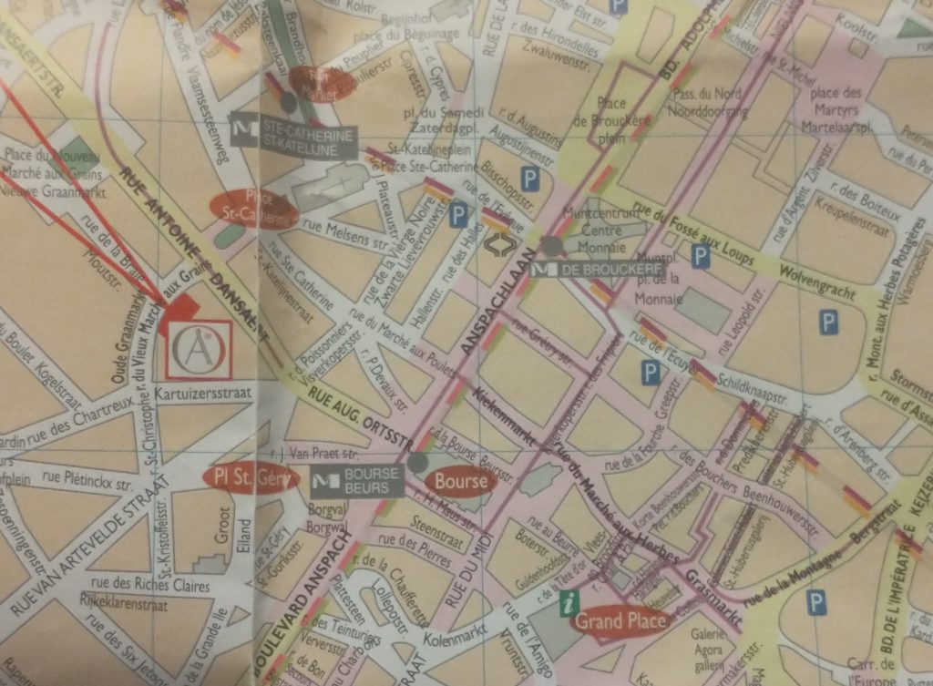
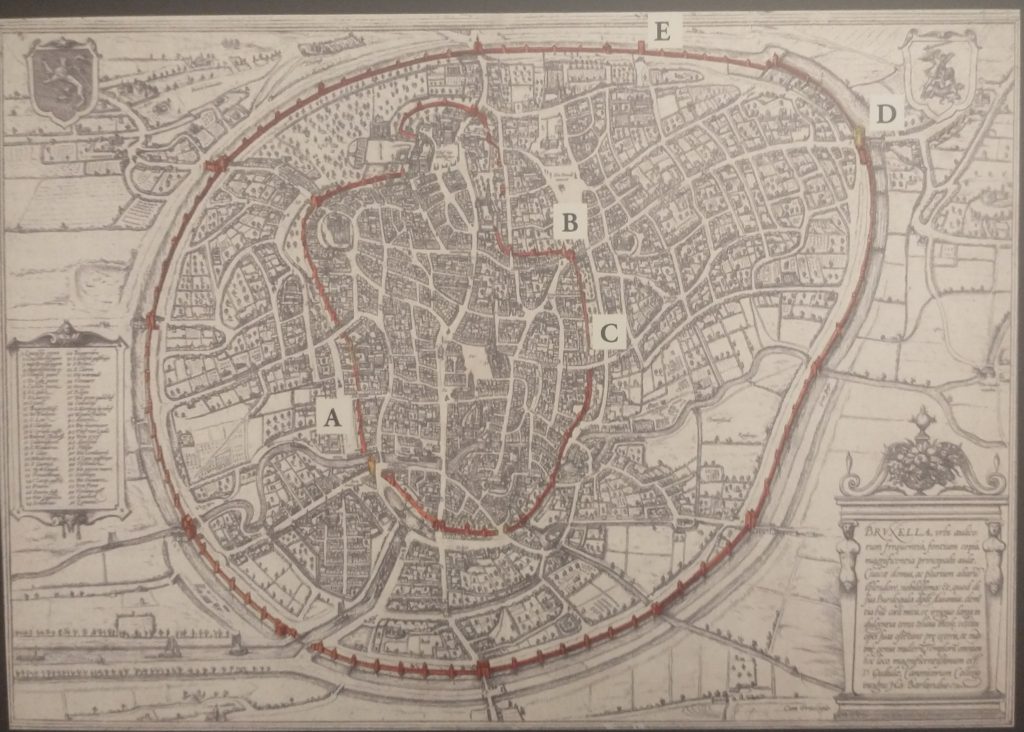
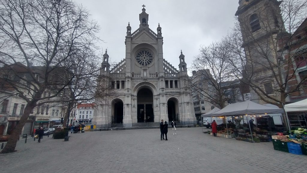
Modern map of central Brussels. The Bourse is a red circle near the centre.
The map of the centre of Brussels shows the area where I have identified topographical evidence of an early Wall circuit. The two red lines coming from the top left point to a red rectangle which is on the curved road called ‘Vieux Marché aux Grains’. This road follows the curved line of the NE section of the wall and was confirmed by the discovery of a surviving section of the Wall on it (see previous posts).
So, on my 4th and last day in Brussels I want to find the rest of this circuit. If you look at the map you can convince yourself there is a circular route – Rue des Riches Clares (Street of the Clare nuns); Rue des Teinturies (Street of Dyers); Kolenmarkt (Coal Market) and to the Grand Place. But I can find nothing that proves it and its a bit weird to have the Town Square (Grand Place) of the town outside the circuit. Maybe this is because the Bourse was the original centre of gravity I wondered? Whatever the case, the roads have the irregularity of medieval town centre streets.
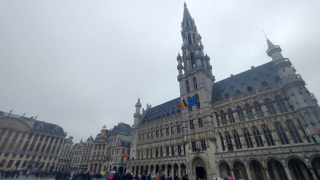
The Town Hall Grand Place, Brussels
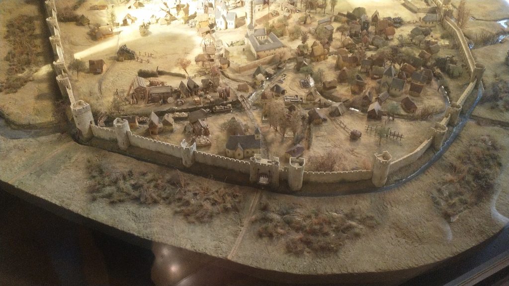
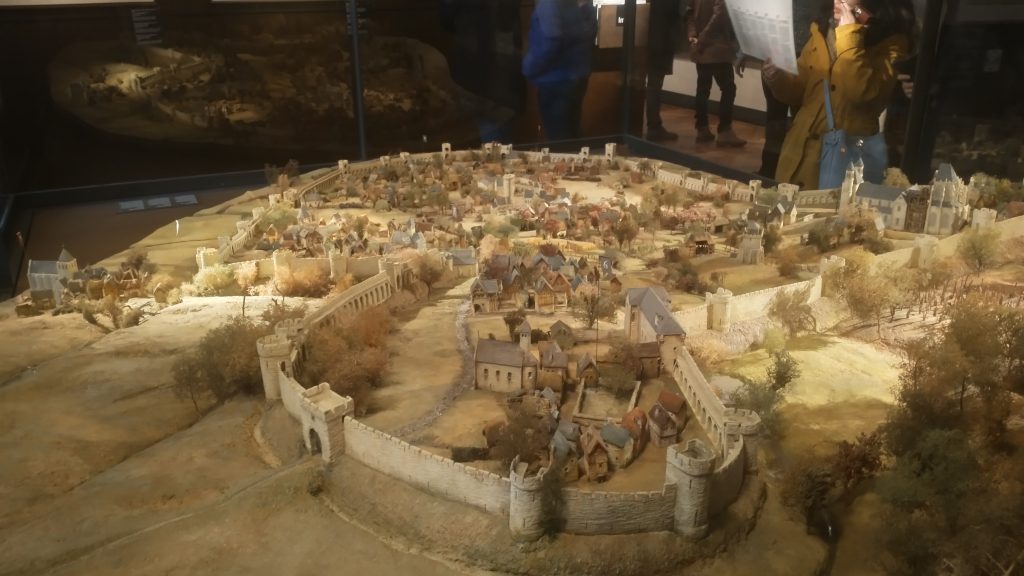
It started to rain so decided to see about a guided tour of the Town Hall, but the attendant suggested I’d be better off at the free ‘House of the King’ across the square which I discover with rising excitement is subtitled ‘The Brussels City Museum.’ Initially I’m disappointed as it is full of fragments of Gothic statues, but upstairs, I strike pay dirt with not only maps, engravings and photographs of the Old Wall Circuit but also a massive model.
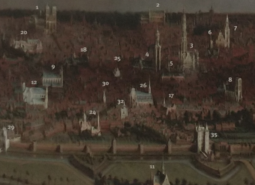
Model of 13th Century Wall Circuit of Brussels. (looking South West)
It takes me a lot of time to work out what is what and which direction we are looking. But the section of the wall at the bottom of the photo above is the wall I identified on the Vieux Marché aux Grains. St Catherine’s is the Church seen just inside the Wall, just to the left of the Gate at the middle bottom of the photo. Other evidence makes it clear that the present day St Catherine’s was moved a little to the left (east).
So, a confirmation of sorts, but also a revelation, in that a river is flowing just behind the wall, and the wall circuit is much bigger than I suspected.
The River is the Senne, it was navigable to an extent taking 8 days to take cargoes to the River Schelde. The River is completely gone, and I think the other part of the wall I pencilled in was actually not the wall but roads following the route of the River.
The River Senne, originally the reason for the foundation of Brussels, became a stinking sewer and was filled in leaving no trace, except the roads that ran alongside it or replaced it.
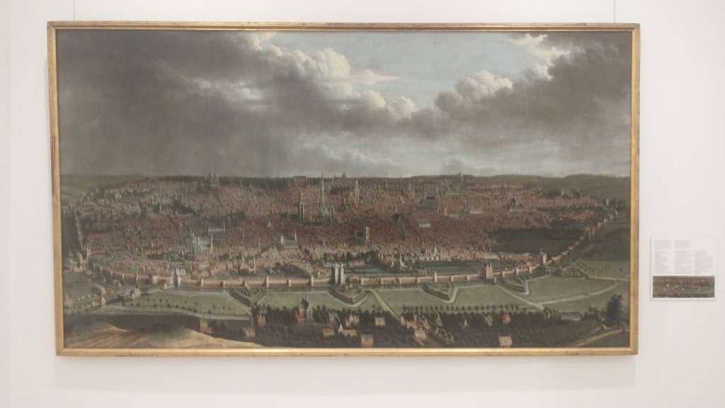
Detail labelled copy of panoramic painting of Brussels c1665 by Jean-Baptiste Bonnercroy. Looking South West
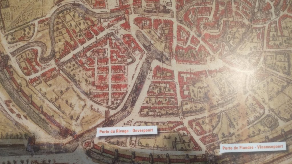
The River was augmented and then replaced by a Canal, which reduced the journey time to the Schelde to one day. The Canal came into the expanded City at no 29 (above_ which is the River gate of the 2nd Wall circuit, and, you might just be able to see a wide street going diagonally from 29 towards no 26, which is St Catherine’s Church. This street used to be the new canal, now a dry linear park and market place.
Detail of Braun & Hogenberg map of 1572, showing the canal entering at Porte De Rivage.
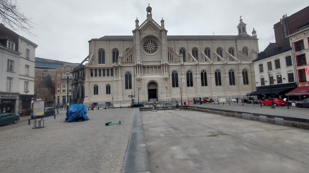
At the end of the canal was a T-Junction so that boats could turn around. When this was filled in and reclaimed St Catherine’s was moved and rebuilt in this space. The Wall was just south of the t-Junction and No 30 in the panorama is the Black Tower, part of the original 13th Century Wall Circuit.
St Catherine’s, built over the old t-junction of the canal. The photo is taken from what was once the canal.
But back to my search for the 13th Century Walk circuit. Look below at the whole model you will see how wrong I was about a small roundish early wall circuit.
Model of 13th Century Wall Circuit of Brussels.
This view of the town is the opposite direction to the previous one, so the wall in the far distance was the section I correctly identified. But I had absolutely no idea that the walled area was so large. The bulge in the wall at the front of the picture was on high ground and was original the site of the Duke of Brabant’s Castle, on Coundenberg Hill and founded in the 11th Century. My exploration was not particularly successful, as far as the 13th Century circuit was concerned, as I had no idea where most of the wall circuit was. I was thinking that there must have been a castle on top of the Hill, but didn’t think the wall circuit would be that big.
Brussels itself began as a small trading town on the River Senne and in the marshy valley of the River. It collected grain from the rich area to export to Antwerp and other urban centres.
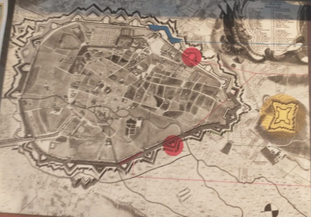
Braun and Hogenberg Plan of Brussels, 1572 showing both wall circuits. North east at the bottom of the plan
The map above shows the two wall circuits. The earliest built 1210 -1230 and the large circuit built in 1357 -1383. That later was extensively developed with the addition of demi-lunettes in 1578, and turned into full bastions in 1671 to cope with the increasing power of artillery. The letters on the plan refer to pictures of the wall that survive.
Panoramic painting of Brussels c1665 by Jean-Baptiste Bonnercroy. Looking South West
The second wall circuit can clearly be seen in the picture above, with Porte de Flandres in the centre, and demi-lunettes in front of the 14th Century Wall.
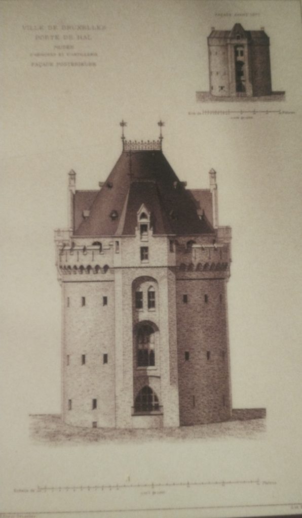
I finished the exploration by finally getting into the 14th Century Gate – Porte de Halle which was wall worth the two trips.
Porte de Halles
This image below will give a good idea of the final form of the defences before they were almost totally demolished and replaced by a ring road.
The late 17th Century Defences of Brussels.
So all in all Brussels is a very interesting City with great museums, amazing pubs/bars, fabulous remains of Art Nouveau dotted around, and an interesting history. As to my exploration, very enjoyable, a little disappointed I didn’t find the River, or identify more of the 13th Century Circuit. With another day I would have walked the entire 13th and 14th Century circuits. But I suspect the surgeon who did my hernia operation would have thought I overdid it as it was.
modern map of central Brussels. The Bourse is a red circle near the centre.
So my next task is to confirm the earlier wall circuit on the map.
To remind you I have tentatively identified the street called the’ Vieux Marché aux Grains’ as a section of an earlier wall circuit surrounding Brussels. On the map above the two red lines coming from the top left point to a red rectangle which is on the Vieux Marché. Walking along it you soon come to a beautiful church dedicated to St Catherine. It must be either just inside, just outside or on top of my walk circuit.
St Catherine’s, Brussels
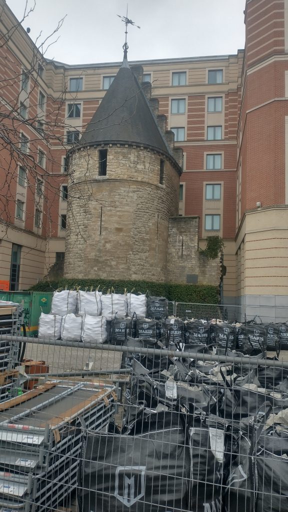
I walk into the church, photograph lots of saints and walk out and there just beyond it is the confirmation that I’m right. There is a beautiful interval Tower and, just to make it certain, it has sections of wall coming out from it. So this the earlier wall circuit. Looks medieval, a century or two earlier than the Porte de Halles.
The Black Tower, Brussels
So, I’m feeling pleased with myself. Two wall circuits confirmed, the outer one I know where the entire circuit is and that it has all been swept away and replaced by an urban ring road except a couple (?) of fragments.
The inner circuit I have only confirmed one section, I know one more bit of it exists or did exist but pretty sure not much else. I’m thinking from the street pattern that it is a small roundish circuit, but nothing is clear from the street pattern apart from this one street.
Feeling smug although I am aware this is a strange game I play with myself. I could just Google ‘Brussels Town Walls’ and I would have most of the answers instantly but the fun of the game is to find it out yourself through topographical clues.
I do it, I think, partly to honour my friend, David Bentley, who died of motor neurone disease a good few years ago but not before we had many stimulating discussions on topographical clues to urban history. Also, it really helps you understand the City, it will tell you why particular roads are important, and give the history of the growth of the town. Since I lost David it is often a solitary game as it needs a very tolerant person to put up with following leads to frequent dead ends and someone who can share the thrill of finding a small fragment of ‘wall’ in exactly the predicted place.
One more discovery before I end. There is a linear ‘park’ coming down from the Porte Flandres, it is lined with what remind me of canalside houses in Bruges, and this seems to be the original route of the canal that was built to link Brussels to the Scheldt. I was told that the canal was diverted when they built the new walk circuit so this seems to be the original course. It comes down to the side of St Catherine’s.
Filled in Canal leading to St Catherine’s. Fish restaurants to the right and you can just see the Black Tower to the left of the Church.
I have no idea how the boats turned around but the grain market was to the right and the fish restaurants suggest this is where fish were landed.
Tomorrow, you will find out if my smugness is confirmed after I decide it is time to check the facts and leave speculation behind.
Panoramic painting of Brussels c1665 by Jean-Baptiste Bonnercoy.
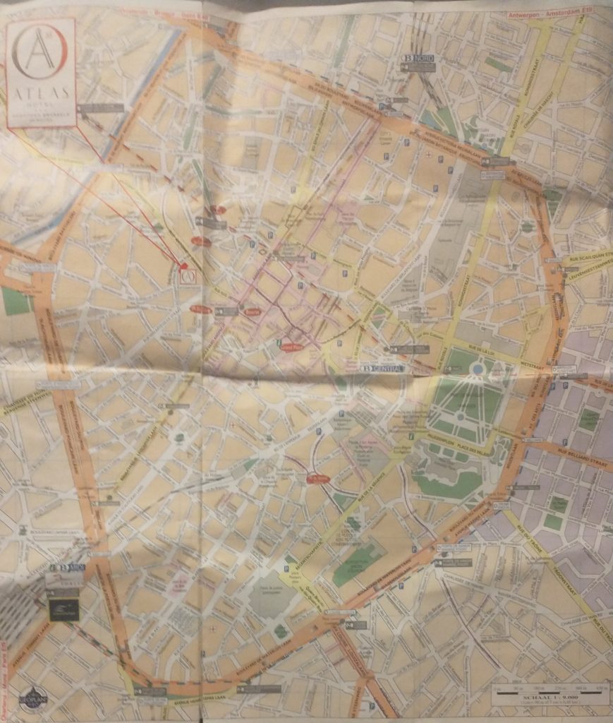
So I arrived at the hotel in Brussels. Got their free map and looked for likely Wall circuits.
Creased Map of Brussels
As you will see there is an extensive inner ring road or boulevard clearly marked in orange. This is, I thought probably the Renaissance wall alignment when the town had expanded and the old walls became useless in the face of cannons.
A closer look at the map confirms it was a wall circuit as at junctions there is a grey label saying ‘Porte de Flandres’ or similar.
So the next task is to find if there was an earlier wall circuit on the map. I’m basically looking for curved roads that were originally just inside the walls or just outside.
modern map of central Brussels. The Bourse is a red circle near the centre.
The two red lines coming from the top left point to a red rectangle which is my hotel and by chance is on a curved road which is my guess to be the early wall circuit. It is called the ‘Vieux Marché aux Grains’. I had a quick explore before retiring for the night. But found nothing conclusive and St Catherine’s Church is astride it.
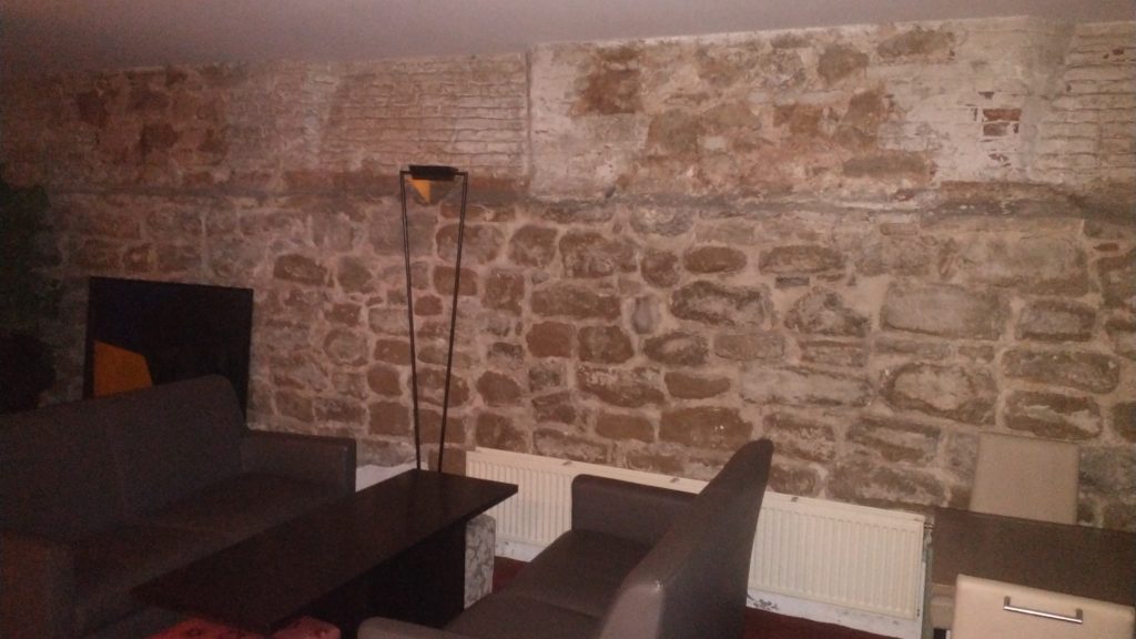
At breakfast, in the basement I failed to notice that 3 of the 4 walls were ancient stone, and there was a picture of a wall and bastion tower. These were pointed out by a staff member, and they suggested they were part of the wall.
Basement cafe of Hotel Atlas
The walls in the basement formed three sides of a rectangle so I had my doubts whether it was ‘the wall’ but it could be a tower or a building built up against the wall. But the picture certainly confirmed my guess that this curved street marked the route of the early wall.
Picture of the wall
So next I walked up to the ‘Porte de Flandres’ in the north east of the town on what I am calling the Renaissance circuit. I wanted to see if any gate or wall survived (no) and to look at the canal which runs alongside the wall.
Then to visit Brussels amazing museums where in the Old Masters museum was found the view of the walls that you will find above. The view is from the north east and at the bottom you will see the canal that linked Brussels to the main trade routes with triangular ramparts in front designed to withstand cannon fire, with the canal and the wall behind. Right in the centre of the bottom is the Porte de Flandres. It looks 15th Century to me, give or take a century but the triangular ramparts look 17th Century.
At the Museum were leaflets to a Porte de Halle museum, So I went from the Musee d’Arte et D’ Histoire, through the European Parliament to the old Wall circuit past several old gates which no longer exist and then saw the view below of the Porte de Halle.
Porte de Halle, Brussels
It looks like something from the Très Riches Heures du Duc de Berry which is early 15th Century. I couldn’t confirm because the gatekeeper of the Porte refused entry as, he said, last entry was at 4pm (1 arrived at 4.03pm) although the leaflet clearly says last entry is 45 mins prior to closing at 5pm.
So I went to confirm the existence of the earlier wall circuit. And I will post about that later.