
I have updated my November 1st Post to include, among other improvements, new pictures of the Day of the Dead in Mexico.
The End of Hardy’s tree
I published the following post about Hardy’s Tree on 28th December 2022. Here, follows the original post and an update which suggests the tree and the gravestones were not erected by Thomas Hardy.
This is the day that Herod ordered the slaughter of the Innocents, or Childermas, and I am glad to see that my Grandson is now older than Herod’s prescription.
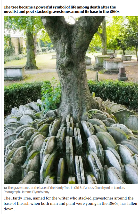
Hardy’s Tree in St Pancras Church, Camden, London has fallen down. Hardy was an architect and worked in London for a while, where one of his jobs was to supervise the clearance of the graveyard. Several poems of Hardy refer to the removal of graves from their original positions and in this case, the gravestones were set around an Ash tree that inspires many, including my Central St Martin’s students who used it in a project recently. So, I was shocked to read a Guardian article (since deleted) which noted the sad demise of the Tree.
Extracts from one of several Hardy Poems about moving graves and gravestones follow, but I need to update the post about the connection to Hardy. The Guardian has now got an article which suggests the connection with Hardy is a more recent one than previously thought (Guardian article).
I (and I think the Guardian) were alerted to this by the work of Lester Hillman, who wrote a Churchyard Guide and a recent pamphlet about the Tree, which is reported in ‘Context ISSN 1462-7574’. This is the Journal of the City of London Archaeological Society. Evidence proves that the Ash Tree dates to the 1930s, and that the mound of gravestones is from burials relocated from St Giles in the Fields, and therefore unlikely to have been in St Pancras at the time Hardy was responsible for clearing it.
So it is not ‘the’ Hardy Tree, but then nor was the tree at Sycamore Gap anything to do with Robin Hood. What it was, was a beautiful piece of nature, in a poignant setting. May she rest in peace.
The Levelled Churchyard
Thomas Hardy
O Passenger, pray list and catch
Our sighs and piteous groans,
Half stifled in this jumbled patch
Of wrenched memorial stones!We late-lamented, resting here,
Are mixed to human jam,
And each to each exclaimed in fear,
I know not which I am.Where we are huddled none can trace,
And if our names remain,
They pave some path or porch or place
Where we have never lain!
Fury in France at Destruction of 7,000 Year-Old Standing Stones June 2023
Salon IF reported a shocking destruction in France – this is the report, verbatim from Salon IF issue 514.

Dozens of standing stones, erected over 7,000 years ago, have been demolished to make way for a DIY store near Carnac, in Brittany, in North West France. Some 37 stones, measuring between 0.5 – 1.5m tall, were removed despite the fact the site had long been on France’s National Archaeological Map. The stones, moreover, had been submitted to the tentative list of UNESCO World Heritage Sites (although the application had not yet been approved).
The region of Carnac is famous for its ancient ‘menhir’ – heavy, raised standing stones. Indeed, the area is often described as ‘the French Stonehenge’, with over 3,000 stone megaliths at the two sites of Menec and Kermario. There, the stone columns are arranged in long, straight rows and, according to the Carnac Tourist Office, it is the largest gathering of this type of standing stone in the world.
The land at the centre of the recent controversy, along the Montauban activity zone, had been granted a building permit by the local mayor’s office in August 2022 and construction of the new store, ‘Mr Bricolage’, was already underway. According to local amateur archaeologist, Christian Obeltz, who had originally raised concerns about the ‘brutal developments’, a bulldozer destroyed the stones overnight.
The Regional Office of Cultural Affairs for Brittany, the body responsible for the protection of the monument, said ‘Given the uncertain and in any case non-major character of the remains, as revealed by

checks, damage to a site of archaeological value has not been established’, but Obeltz maintains that archaeological investigation into the area had not been sufficient.
‘The Chemin de Montauban site included two intersecting rows of small granite stelae, each spreading out over fifty meters in length. One had been exactly in its original place for 7,000 years,’ according to Obletz. ‘The small menhirs of the Chemin de Montauban were undoubtedly one of the oldest sets of stelae in the town of Carnac’ believed to date between 5480 and 5320 BC, ‘the highest dating obtained for a menhir in the west of France’.
May 18th Ascension Day beating the bounds
Here, is an interesting account from the web site of the Historic Royal Palaces about marking the boundary of a Parish in the ceremony known as ‘beating the bounds’.
Digital Heritage – The Past Deciphered by AI
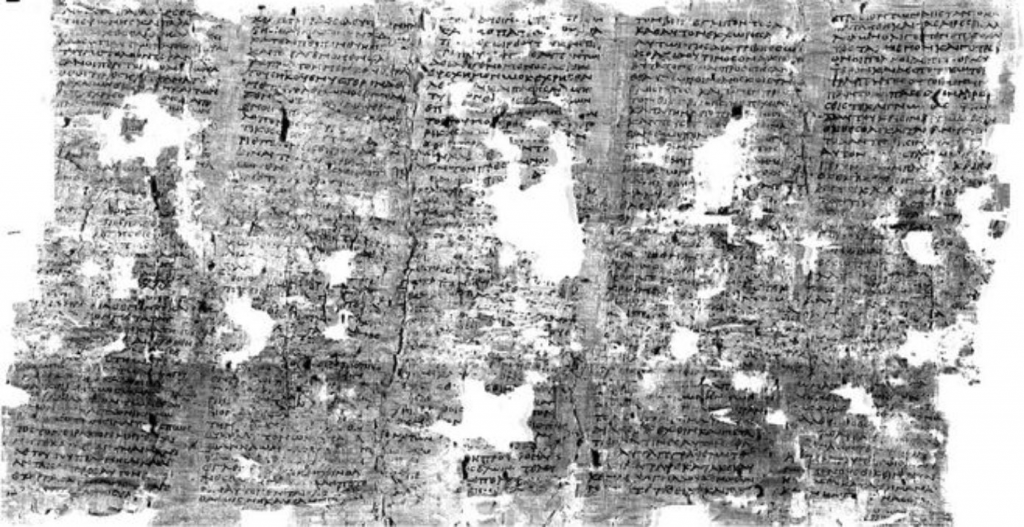
This is one of the most exciting advances I have read about for a long time! A pile of burnt scrolls survive from the Villa dei Papiri, Herculaneum. They are being examined by several teams from American Universities including the University of Michigan, and the University of Kentucky. They are just beginning to read fragments of the texts, using all the scientific techniques they can throw at it including AI. The AI has begun to learn to read fragments of the tightly rolled scroll.
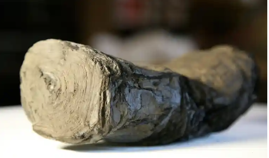
The scroll they are working on appears to be a piece about Alexander the Great and his legacy. It is an unknown text or to put it another way, it is potentially a brand new source of information for this period of time. It has been suggested that it might possibly be a copy of the lost diary of Alexander’s secretary, Eumenos or may have been written by a friend of the general Antigonos. Either way, potentially eye witness accounts. Or not, as perhaps, they may be asking too much from the first investigation. It may be more prosaic. Time will tell.
The implications, however, are so exciting! Just as the amazing excavations at Stonehenge (and indeed in London) have revolutionised our knowledge of these places, so AI could introduce completely new insights into the past. There are many rolls that were burnt in the collection, but now AI is beginning to read them. what insights we might get even from small fragments? One of the scholars involved is particularly excited to imagine the discoveries that could be forthcoming from the Middle East
‘While others would love to see some of the lost work of the ancients, what I’d like to see is evidence of the turmoil that was happening in the first century around the development of Christianity and the Judeo-Christian tradition as it was evolving.’
Brent Seales, University of Kentucky
But those ‘lost works of the ancients’. There are so many that would rock history: Tacitus’s ‘Annals’ missing missing the last two years of Nero’s reign. Pytheas ‘On the Ocean’ with its first references to Britain in writing. 6 Plays of Aeschylus, 9 Books of Sappho and the list goes on. Have a look at Charlotte Higgins piece in Prospect Magazine for a little more detail.
Another feature of the study is that the teams have released images to the cloud and are encouraging others to ‘have a go’ at reading them. This shows the strides that Citizen Science has made, and how, scientists acknowledge that, in the days of big data, cooperation pays huge dividends.
My source of information is the marvellous The Society of Antiquaries of London Online Newsletter (Salon) which ‘is a fortnightly digest of heritage news‘ and for more information look at Issue 509.
Another source is Interestingengineering.com.
Testing 360deg
I’m testing a new 360 degree plugin
Brussels 4 Best to read the better proof-read version
I was a hurry to get it finished. So if you haven’t read it read it yet this updated version makes more sense and has some extra details:
Town exploration: 4 Brussels
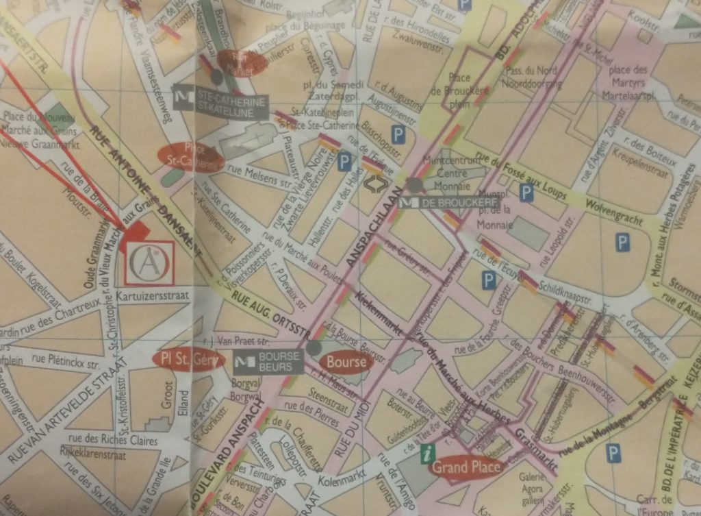
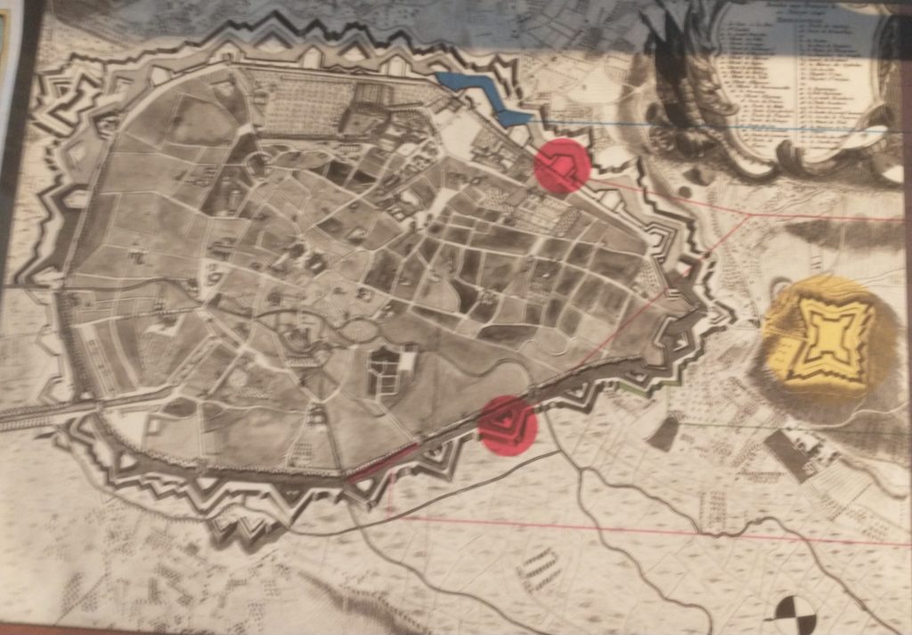
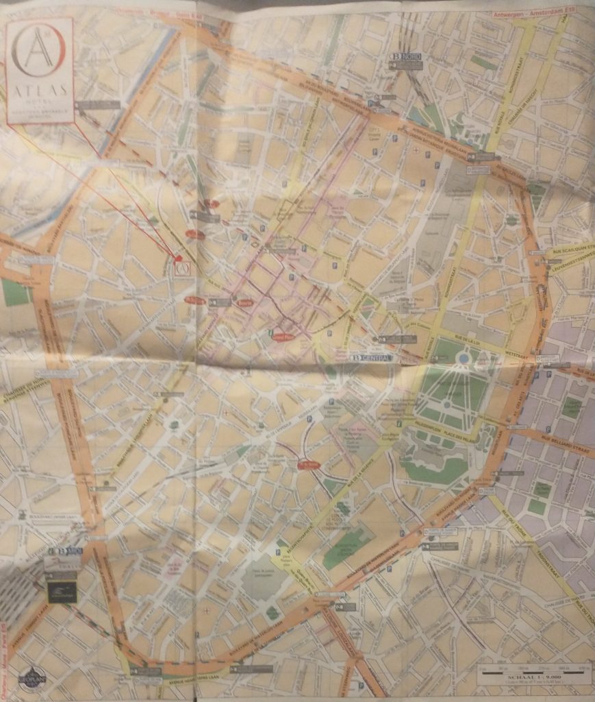
The map of the centre of Brussels shows the area where I have identified topographical evidence of an early Wall circuit. The two red lines coming from the top left point to a red rectangle which is on the curved road called ‘Vieux Marché aux Grains’. This road follows the curved line of the NE section of the wall and was confirmed by the discovery of a surviving section of the Wall on it (see previous posts).
So, on my 4th and last day in Brussels I want to find the rest of this circuit. If you look at the map you can convince yourself there is a circular route – Rue des Riches Clares (Street of the Clare nuns); Rue des Teinturies (Street of Dyers); Kolenmarkt (Coal Market) and to the Grand Place. But I can find nothing that proves it and its a bit weird to have the Town Square (Grand Place) of the town outside the circuit. Maybe this is because the Bourse was the original centre of gravity I wondered? Whatever the case, the roads have the irregularity of medieval town centre streets.
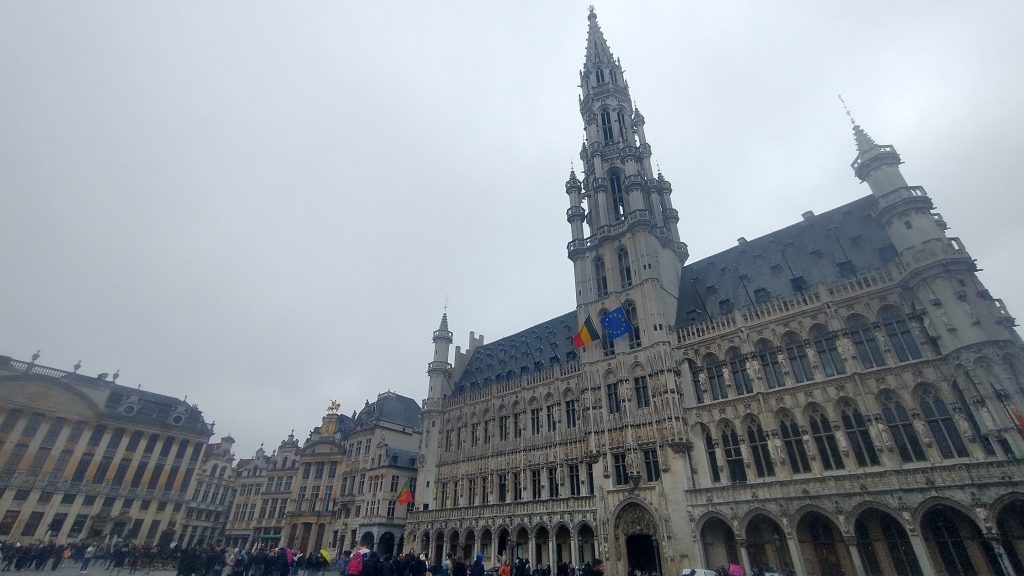
It started to rain so decided to see about a guided tour of the Town Hall, but the attendant suggested I’d be better off at the free ‘House of the King’ across the square which I discover with rising excitement is subtitled ‘The Brussels City Museum.’ Initially I’m disappointed as it is full of fragments of Gothic statues, but upstairs, I strike pay dirt with not only maps, engravings and photographs of the Old Wall Circuit but also a massive model.
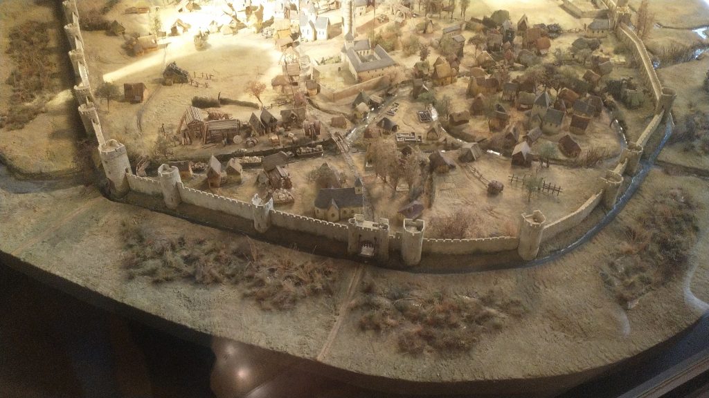
It takes me a lot of time to work out what is what and which direction we are looking. But the section of the wall at the bottom of the photo above is the wall I identified on the Vieux Marché aux Grains. St Catherine’s is the Church seen just inside the Wall, just to the left of the Gate at the middle bottom of the photo. Other evidence makes it clear that the present day St Catherine’s was moved a little to the left (east).
So, a confirmation of sorts, but also a revelation, in that a river is flowing just behind the wall, and the wall circuit is much bigger than I suspected.
The River is the Senne, it was navigable to an extent taking 8 days to take cargoes to the River Schelde. The River is completely gone, and I think the other part of the wall I pencilled in was actually not the wall but roads following the route of the River.
The River Senne, originally the reason for the foundation of Brussels, became a stinking sewer and was filled in leaving no trace, except the roads that ran alongside it or replaced it.
The River was augmented and then replaced by a Canal, which reduced the journey time to the Schelde to one day. The Canal came into the expanded City at no 29 (above_ which is the River gate of the 2nd Wall circuit, and, you might just be able to see a wide street going diagonally from 29 towards no 26, which is St Catherine’s Church. This street used to be the new canal, now a dry linear park and market place.
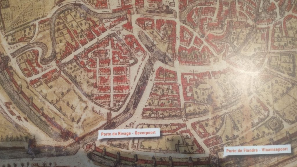
At the end of the canal was a T-Junction so that boats could turn around. When this was filled in and reclaimed St Catherine’s was moved and rebuilt in this space. The Wall was just south of the t-Junction and No 30 in the panorama is the Black Tower, part of the original 13th Century Wall Circuit.
But back to my search for the 13th Century Walk circuit. Look below at the whole model you will see how wrong I was about a small roundish early wall circuit.
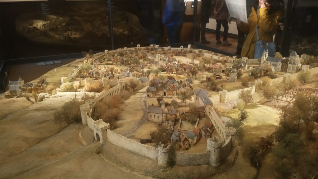
This view of the town is the opposite direction to the previous one, so the wall in the far distance was the section I correctly identified. But I had absolutely no idea that the walled area was so large. The bulge in the wall at the front of the picture was on high ground and was original the site of the Duke of Brabant’s Castle, on Coundenberg Hill and founded in the 11th Century. My exploration was not particularly successful, as far as the 13th Century circuit was concerned, as I had no idea where most of the wall circuit was. I was thinking that there must have been a castle on top of the Hill, but didn’t think the wall circuit would be that big.
Brussels itself began as a small trading town on the River Senne and in the marshy valley of the River. It collected grain from the rich area to export to Antwerp and other urban centres.
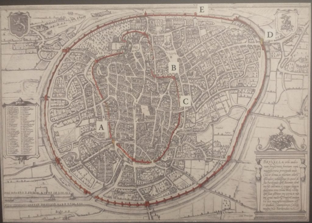
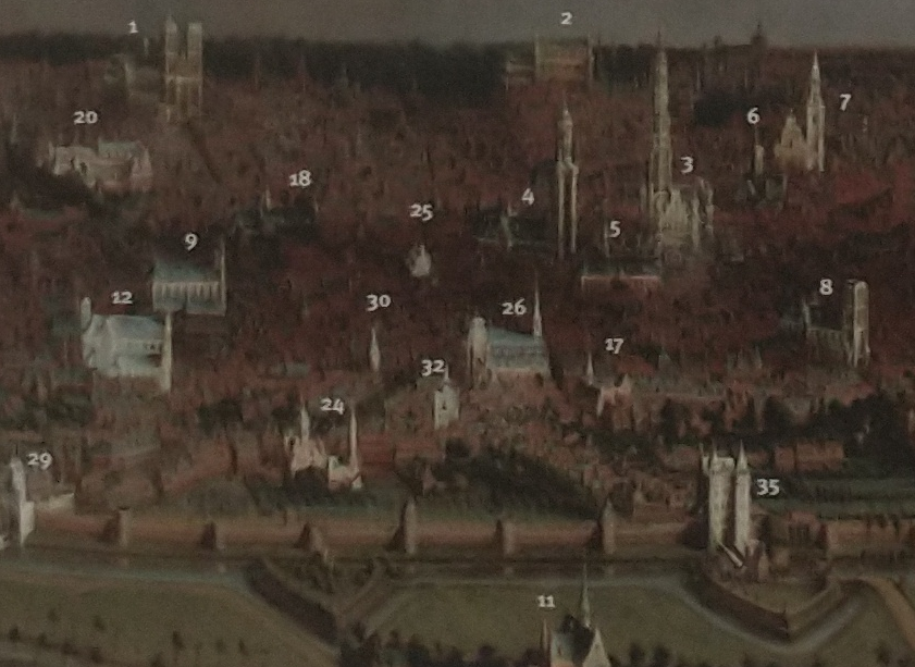
The map above shows the two wall circuits. The earliest built 1210 -1230 and the large circuit built in 1357 -1383. That later was extensively developed with the addition of demi-lunettes in 1578, and turned into full bastions in 1671 to cope with the increasing power of artillery. The letters on the plan refer to pictures of the wall that survive.
The second wall circuit can clearly be seen in the picture above, with Porte de Flandres in the centre, and demi-lunettes in front of the 14th Century Wall.
I finished the exploration by finally getting into the 14th Century Gate – Porte de Halle which was wall worth the two trips.
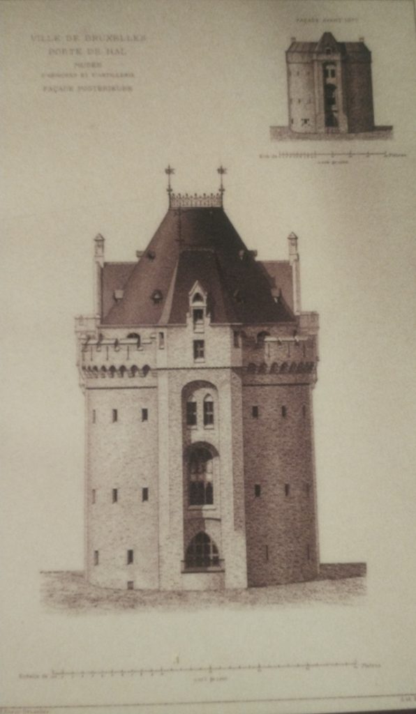
This image below will give a good idea of the final form of the defences before they were almost totally demolished and replaced by a ring road.
So all in all Brussels is a very interesting City with great museums, amazing pubs/bars, fabulous remains of Art Nouveau dotted around, and an interesting history. As to my exploration, very enjoyable, a little disappointed I didn’t find the River, or identify more of the 13th Century Circuit. With another day I would have walked the entire 13th and 14th Century circuits. But I suspect the surgeon who did my hernia operation would have thought I overdid it as it was.
Town exploration: 3 Brussels
So my next task is to confirm the earlier wall circuit on the map.
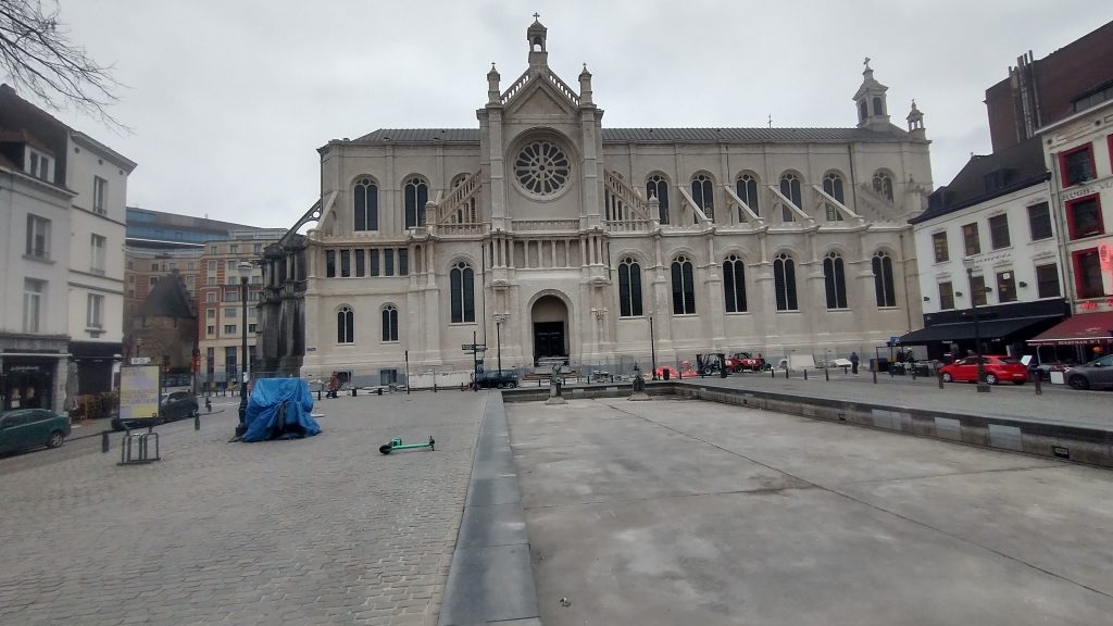
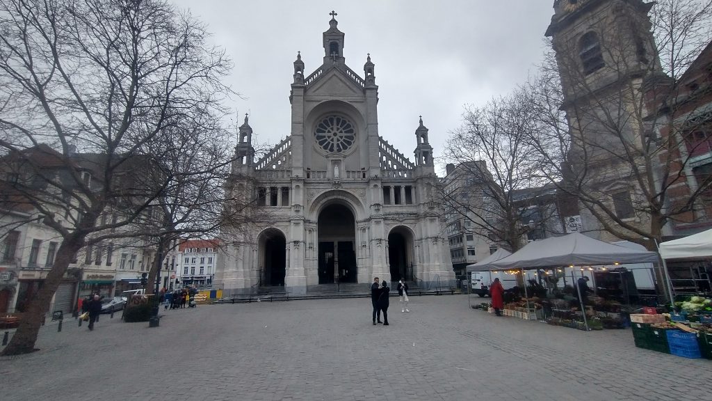
To remind you I have tentatively identified the street called the’ Vieux Marché aux Grains’ as a section of an earlier wall circuit surrounding Brussels. On the map above the two red lines coming from the top left point to a red rectangle which is on the Vieux Marché. Walking along it you soon come to a beautiful church dedicated to St Catherine. It must be either just inside, just outside or on top of my walk circuit.
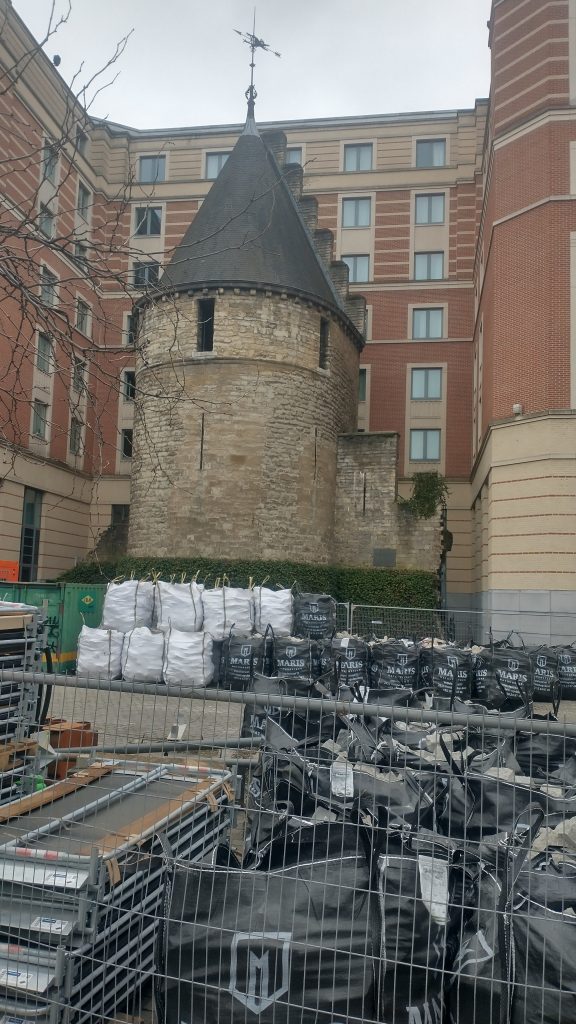
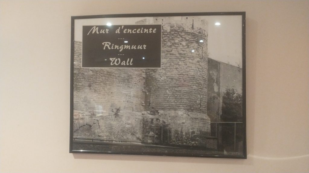
I walk into the church, photograph lots of saints and walk out and there just beyond it is the confirmation that I’m right. There is a beautiful interval Tower and, just to make it certain, it has sections of wall coming out from it. So this the earlier wall circuit. Looks medieval, a century or two earlier than the Porte de Halles.
So, I’m feeling pleased with myself. Two wall circuits confirmed, the outer one I know where the entire circuit is and that it has all been swept away and replaced by an urban ring road except a couple (?) of fragments.
The inner circuit I have only confirmed one section, I know one more bit of it exists or did exist but pretty sure not much else. I’m thinking from the street pattern that it is a small roundish circuit, but nothing is clear from the street pattern apart from this one street.
Feeling smug although I am aware this is a strange game I play with myself. I could just Google ‘Brussels Town Walls’ and I would have most of the answers instantly but the fun of the game is to find it out yourself through topographical clues.
I do it, I think, partly to honour my friend, David Bentley, who died of motor neurone disease a good few years ago but not before we had many stimulating discussions on topographical clues to urban history. Also, it really helps you understand the City, it will tell you why particular roads are important, and give the history of the growth of the town. Since I lost David it is often a solitary game as it needs a very tolerant person to put up with following leads to frequent dead ends and someone who can share the thrill of finding a small fragment of ‘wall’ in exactly the predicted place.
One more discovery before I end. There is a linear ‘park’ coming down from the Porte Flandres, it is lined with what remind me of canalside houses in Bruges, and this seems to be the original route of the canal that was built to link Brussels to the Scheldt. I was told that the canal was diverted when they built the new walk circuit so this seems to be the original course. It comes down to the side of St Catherine’s.
I have no idea how the boats turned around but the grain market was to the right and the fish restaurants suggest this is where fish were landed.
Tomorrow, you will find out if my smugness is confirmed after I decide it is time to check the facts and leave speculation behind.
Town exploration: 2 Brussels
So I arrived at the hotel in Brussels. Got their free map and looked for likely Wall circuits.
As you will see there is an extensive inner ring road or boulevard clearly marked in orange. This is, I thought probably the Renaissance wall alignment when the town had expanded and the old walls became useless in the face of cannons.
A closer look at the map confirms it was a wall circuit as at junctions there is a grey label saying ‘Porte de Flandres’ or similar.
So the next task is to find if there was an earlier wall circuit on the map. I’m basically looking for curved roads that were originally just inside the walls or just outside.
The two red lines coming from the top left point to a red rectangle which is my hotel and by chance is on a curved road which is my guess to be the early wall circuit. It is called the ‘Vieux Marché aux Grains’. I had a quick explore before retiring for the night. But found nothing conclusive and St Catherine’s Church is astride it.
At breakfast, in the basement I failed to notice that 3 of the 4 walls were ancient stone, and there was a picture of a wall and bastion tower. These were pointed out by a staff member, and they suggested they were part of the wall.
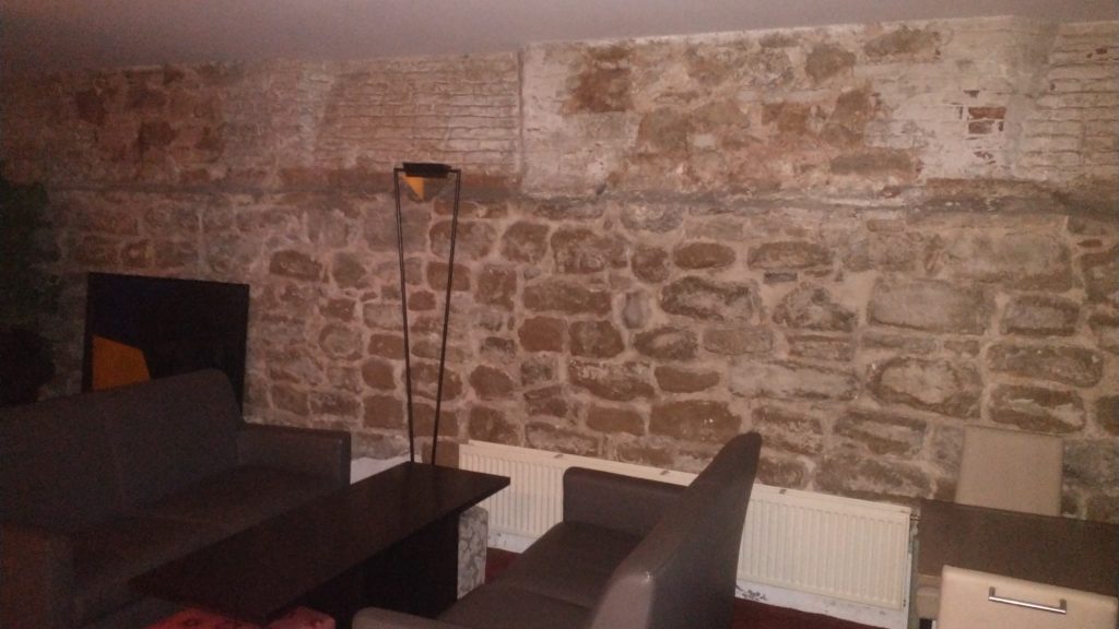
The walls in the basement formed three sides of a rectangle so I had my doubts whether it was ‘the wall’ but it could be a tower or a building built up against the wall. But the picture certainly confirmed my guess that this curved street marked the route of the early wall.
So next I walked up to the ‘Porte de Flandres’ in the north east of the town on what I am calling the Renaissance circuit. I wanted to see if any gate or wall survived (no) and to look at the canal which runs alongside the wall.
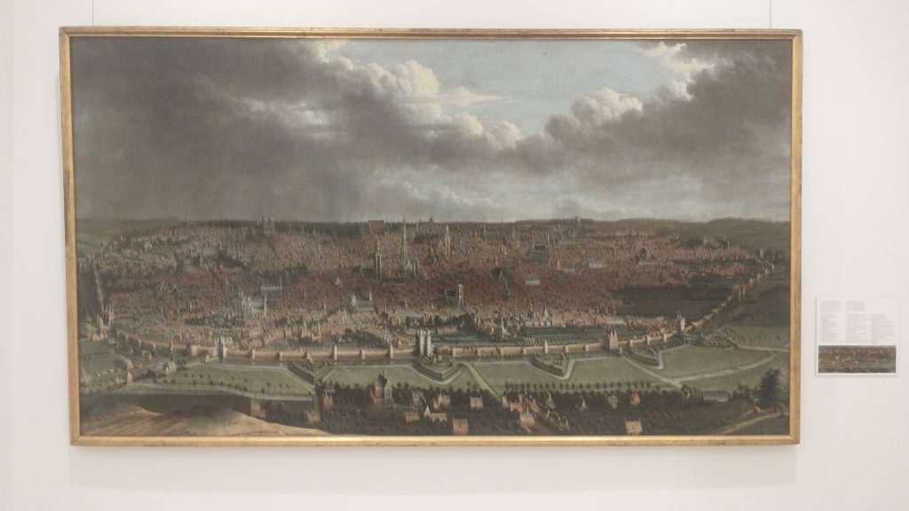
Then to visit Brussels amazing museums where in the Old Masters museum was found the view of the walls that you will find above. The view is from the north east and at the bottom you will see the canal that linked Brussels to the main trade routes with triangular ramparts in front designed to withstand cannon fire, with the canal and the wall behind. Right in the centre of the bottom is the Porte de Flandres. It looks 15th Century to me, give or take a century but the triangular ramparts look 17th Century.
At the Museum were leaflets to a Porte de Halle museum, So I went from the Musee d’Arte et D’ Histoire, through the European Parliament to the old Wall circuit past several old gates which no longer exist and then saw the view below of the Porte de Halle.
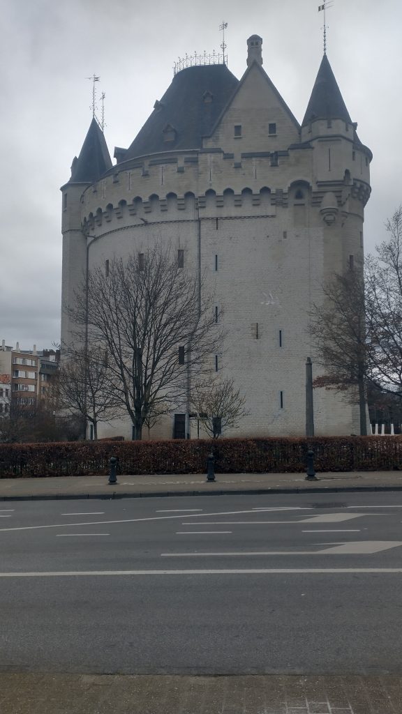
It looks like something from the Très Riches Heures du Duc de Berry which is early 15th Century. I couldn’t confirm because the gatekeeper of the Porte refused entry as, he said, last entry was at 4pm (1 arrived at 4.03pm) although the leaflet clearly says last entry is 45 mins prior to closing at 5pm.
So I went to confirm the existence of the earlier wall circuit. And I will post about that later.